LPAZ La Paz , Bolivia - Earthquake Result Viewer
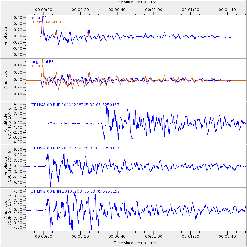
Earthquake location: South Sandwich Islands Region
Earthquake latitude/longitude: -56.4/-25.7
Earthquake time(UTC): 2010/12/08 (342) 05:24:35 GMT
Earthquake Depth: 29 km
Earthquake Magnitude: 6.1 MB, 6.2 MS, 6.3 MW, 6.3 MW
Earthquake Catalog/Contributor: WHDF/NEIC
Network: GT Global Telemetered Seismograph Network (USAF/USGS)
Station: LPAZ La Paz , Bolivia
Lat/Lon: 16.17 S/68.08 W
Elevation: 4817 m
Distance: 51.3 deg
Az: 304.007 deg
Baz: 151.349 deg
Ray Param: 0.067435406
Estimated Moho Depth: 45.5 km
Estimated Crust Vp/Vs: 1.75
Assumed Crust Vp: 6.454 km/s
Estimated Crust Vs: 3.683 km/s
Estimated Crust Poisson's Ratio: 0.26
Radial Match: 92.230705 %
Radial Bump: 400
Transverse Match: 91.17648 %
Transverse Bump: 400
SOD ConfigId: 343951
Insert Time: 2011-05-24 11:52:05.752 +0000
GWidth: 2.5
Max Bumps: 400
Tol: 0.001

Signal To Noise

ChannelStoNSTALTA
GT:LPAZ:00:BHZ:20101208T05:33:05.525015Z54.4569474.573416E-68.3982236E-8
GT:LPAZ:00:BHN:20101208T05:33:05.525015Z34.070321.6854223E-64.9468934E-8
GT:LPAZ:00:BHE:20101208T05:33:05.525015Z18.5877551.7786447E-69.568905E-8
Arrivals
Ps5.6 SECOND
PpPs18 SECOND
PsPs/PpSs24 SECOND