You are here: Home > Network List > CI - Caltech Regional Seismic Network Stations List
> Station TIN Tinemaha, Big Pine, CA, USA > Earthquake Result Viewer
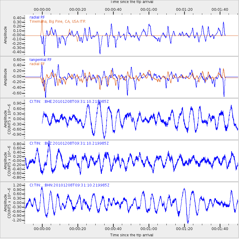
TIN Tinemaha, Big Pine, CA, USA - Earthquake Result Viewer
*The percent match for this event was below the threshold and hence no stack was calculated.
| Earthquake location: |
South Of Kermadec Islands |
| Earthquake latitude/longitude: |
-32.3/-179.5 |
| Earthquake time(UTC): |
2010/12/08 (342) 09:18:47 GMT |
| Earthquake Depth: |
37 km |
| Earthquake Magnitude: |
5.5 MB, 5.0 MS, 5.4 MW |
| Earthquake Catalog/Contributor: |
WHDF/NEIC |
|
| Network: |
CI Caltech Regional Seismic Network |
| Station: |
TIN Tinemaha, Big Pine, CA, USA |
| Lat/Lon: |
37.05 N/118.23 W |
| Elevation: |
1197 m |
|
| Distance: |
89.6 deg |
| Az: |
44.568 deg |
| Baz: |
228.007 deg |
| Ray Param: |
$rayparam |
*The percent match for this event was below the threshold and hence was not used in the summary stack. |
|
| Radial Match: |
50.44464 % |
| Radial Bump: |
400 |
| Transverse Match: |
57.96685 % |
| Transverse Bump: |
330 |
| SOD ConfigId: |
343951 |
| Insert Time: |
2011-05-24 13:04:09.447 +0000 |
| GWidth: |
2.5 |
| Max Bumps: |
400 |
| Tol: |
0.001 |
|
Signal To Noise
| Channel | StoN | STA | LTA |
| CI:TIN: :BHZ:20101208T09:31:10.219985Z | 1.8645624 | 4.525596E-7 | 2.4271625E-7 |
| CI:TIN: :BHN:20101208T09:31:10.219985Z | 2.142826 | 6.8317564E-7 | 3.1881993E-7 |
| CI:TIN: :BHE:20101208T09:31:10.219985Z | 3.4923859 | 6.951732E-7 | 1.9905394E-7 |
| Arrivals |
| Ps | |
| PpPs | |
| PsPs/PpSs | |


