You are here: Home > Network List > TA - USArray Transportable Network (new EarthScope stations) Stations List
> Station 532A Rocksprings, TX, USA > Earthquake Result Viewer
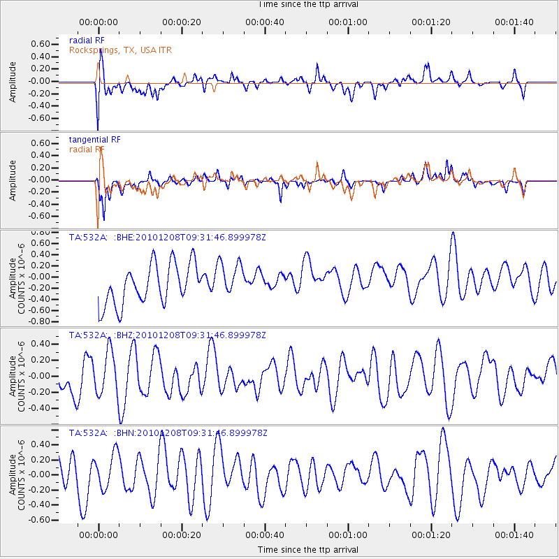
532A Rocksprings, TX, USA - Earthquake Result Viewer
*The percent match for this event was below the threshold and hence no stack was calculated.
| Earthquake location: |
South Of Kermadec Islands |
| Earthquake latitude/longitude: |
-32.3/-179.5 |
| Earthquake time(UTC): |
2010/12/08 (342) 09:18:47 GMT |
| Earthquake Depth: |
37 km |
| Earthquake Magnitude: |
5.5 MB, 5.0 MS, 5.4 MW |
| Earthquake Catalog/Contributor: |
WHDF/NEIC |
|
| Network: |
TA USArray Transportable Network (new EarthScope stations) |
| Station: |
532A Rocksprings, TX, USA |
| Lat/Lon: |
30.13 N/99.90 W |
| Elevation: |
703 m |
|
| Distance: |
97.6 deg |
| Az: |
59.3 deg |
| Baz: |
237.238 deg |
| Ray Param: |
$rayparam |
*The percent match for this event was below the threshold and hence was not used in the summary stack. |
|
| Radial Match: |
47.18156 % |
| Radial Bump: |
400 |
| Transverse Match: |
72.40308 % |
| Transverse Bump: |
400 |
| SOD ConfigId: |
343951 |
| Insert Time: |
2011-05-24 13:15:24.295 +0000 |
| GWidth: |
2.5 |
| Max Bumps: |
400 |
| Tol: |
0.001 |
|
Signal To Noise
| Channel | StoN | STA | LTA |
| TA:532A: :BHZ:20101208T09:31:46.899978Z | 0.9743667 | 2.7820494E-7 | 2.8552387E-7 |
| TA:532A: :BHN:20101208T09:31:46.899978Z | 1.047047 | 2.5375442E-7 | 2.4235248E-7 |
| TA:532A: :BHE:20101208T09:31:46.899978Z | 0.87542343 | 3.1352218E-7 | 3.5813775E-7 |
| Arrivals |
| Ps | |
| PpPs | |
| PsPs/PpSs | |


