You are here: Home > Network List > TA - USArray Transportable Network (new EarthScope stations) Stations List
> Station H28A Mission Ridge, SD, USA > Earthquake Result Viewer
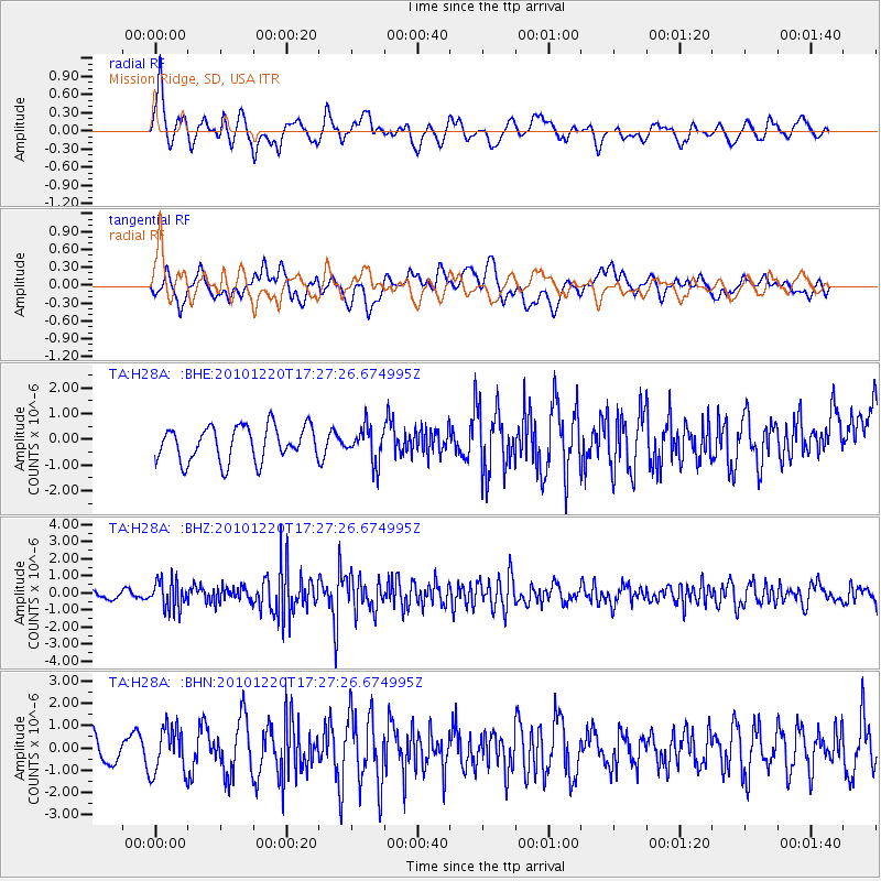
H28A Mission Ridge, SD, USA - Earthquake Result Viewer
*The percent match for this event was below the threshold and hence no stack was calculated.
| Earthquake location: |
Off Coast Of Central America |
| Earthquake latitude/longitude: |
13.0/-88.6 |
| Earthquake time(UTC): |
2010/12/20 (354) 17:21:26 GMT |
| Earthquake Depth: |
72 km |
| Earthquake Magnitude: |
5.5 MB, 5.7 MW, 5.7 MW |
| Earthquake Catalog/Contributor: |
WHDF/NEIC |
|
| Network: |
TA USArray Transportable Network (new EarthScope stations) |
| Station: |
H28A Mission Ridge, SD, USA |
| Lat/Lon: |
44.68 N/101.02 W |
| Elevation: |
642 m |
|
| Distance: |
33.3 deg |
| Az: |
343.822 deg |
| Baz: |
157.626 deg |
| Ray Param: |
$rayparam |
*The percent match for this event was below the threshold and hence was not used in the summary stack. |
|
| Radial Match: |
70.96276 % |
| Radial Bump: |
400 |
| Transverse Match: |
68.25964 % |
| Transverse Bump: |
400 |
| SOD ConfigId: |
343951 |
| Insert Time: |
2011-05-24 15:47:32.434 +0000 |
| GWidth: |
2.5 |
| Max Bumps: |
400 |
| Tol: |
0.001 |
|
Signal To Noise
| Channel | StoN | STA | LTA |
| TA:H28A: :BHZ:20101220T17:27:26.674995Z | 2.3541849 | 8.2815205E-7 | 3.5177865E-7 |
| TA:H28A: :BHN:20101220T17:27:26.674995Z | 1.9594568 | 1.0288287E-6 | 5.2505817E-7 |
| TA:H28A: :BHE:20101220T17:27:26.674995Z | 0.98736227 | 6.6202864E-7 | 6.705023E-7 |
| Arrivals |
| Ps | |
| PpPs | |
| PsPs/PpSs | |


