You are here: Home > Network List > TA - USArray Transportable Network (new EarthScope stations) Stations List
> Station J26A Sides Ranch, Smithwick, SD, USA > Earthquake Result Viewer
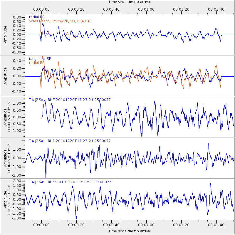
J26A Sides Ranch, Smithwick, SD, USA - Earthquake Result Viewer
*The percent match for this event was below the threshold and hence no stack was calculated.
| Earthquake location: |
Off Coast Of Central America |
| Earthquake latitude/longitude: |
13.0/-88.6 |
| Earthquake time(UTC): |
2010/12/20 (354) 17:21:26 GMT |
| Earthquake Depth: |
72 km |
| Earthquake Magnitude: |
5.5 MB, 5.7 MW, 5.7 MW |
| Earthquake Catalog/Contributor: |
WHDF/NEIC |
|
| Network: |
TA USArray Transportable Network (new EarthScope stations) |
| Station: |
J26A Sides Ranch, Smithwick, SD, USA |
| Lat/Lon: |
43.31 N/103.08 W |
| Elevation: |
993 m |
|
| Distance: |
32.7 deg |
| Az: |
340.305 deg |
| Baz: |
153.253 deg |
| Ray Param: |
$rayparam |
*The percent match for this event was below the threshold and hence was not used in the summary stack. |
|
| Radial Match: |
59.5453 % |
| Radial Bump: |
400 |
| Transverse Match: |
55.124554 % |
| Transverse Bump: |
400 |
| SOD ConfigId: |
343951 |
| Insert Time: |
2011-05-24 15:52:55.063 +0000 |
| GWidth: |
2.5 |
| Max Bumps: |
400 |
| Tol: |
0.001 |
|
Signal To Noise
| Channel | StoN | STA | LTA |
| TA:J26A: :BHZ:20101220T17:27:21.250007Z | 2.403103 | 6.7668157E-7 | 2.8158658E-7 |
| TA:J26A: :BHN:20101220T17:27:21.250007Z | 1.1327351 | 6.5224924E-7 | 5.75818E-7 |
| TA:J26A: :BHE:20101220T17:27:21.250007Z | 1.3566381 | 6.7641986E-7 | 4.986001E-7 |
| Arrivals |
| Ps | |
| PpPs | |
| PsPs/PpSs | |


