You are here: Home > Network List > TA - USArray Transportable Network (new EarthScope stations) Stations List
> Station L31A Butterfield Farm, Chambers, NE, USA > Earthquake Result Viewer
L31A Butterfield Farm, Chambers, NE, USA - Earthquake Result Viewer

| Earthquake location: |
Off Coast Of Central America |
| Earthquake latitude/longitude: |
13.0/-88.6 |
| Earthquake time(UTC): |
2010/12/20 (354) 17:21:26 GMT |
| Earthquake Depth: |
72 km |
| Earthquake Magnitude: |
5.5 MB, 5.7 MW, 5.7 MW |
| Earthquake Catalog/Contributor: |
WHDF/NEIC |
|
| Network: |
TA USArray Transportable Network (new EarthScope stations) |
| Station: |
L31A Butterfield Farm, Chambers, NE, USA |
| Lat/Lon: |
42.18 N/98.84 W |
| Elevation: |
670 m |
|
| Distance: |
30.4 deg |
| Az: |
344.923 deg |
| Baz: |
160.056 deg |
| Ray Param: |
0.07923472 |
| Estimated Moho Depth: |
43.5 km |
| Estimated Crust Vp/Vs: |
1.98 |
| Assumed Crust Vp: |
6.53 km/s |
| Estimated Crust Vs: |
3.302 km/s |
| Estimated Crust Poisson's Ratio: |
0.33 |
|
| Radial Match: |
80.94178 % |
| Radial Bump: |
398 |
| Transverse Match: |
65.84715 % |
| Transverse Bump: |
400 |
| SOD ConfigId: |
343951 |
| Insert Time: |
2011-05-24 15:57:38.768 +0000 |
| GWidth: |
2.5 |
| Max Bumps: |
400 |
| Tol: |
0.001 |
|
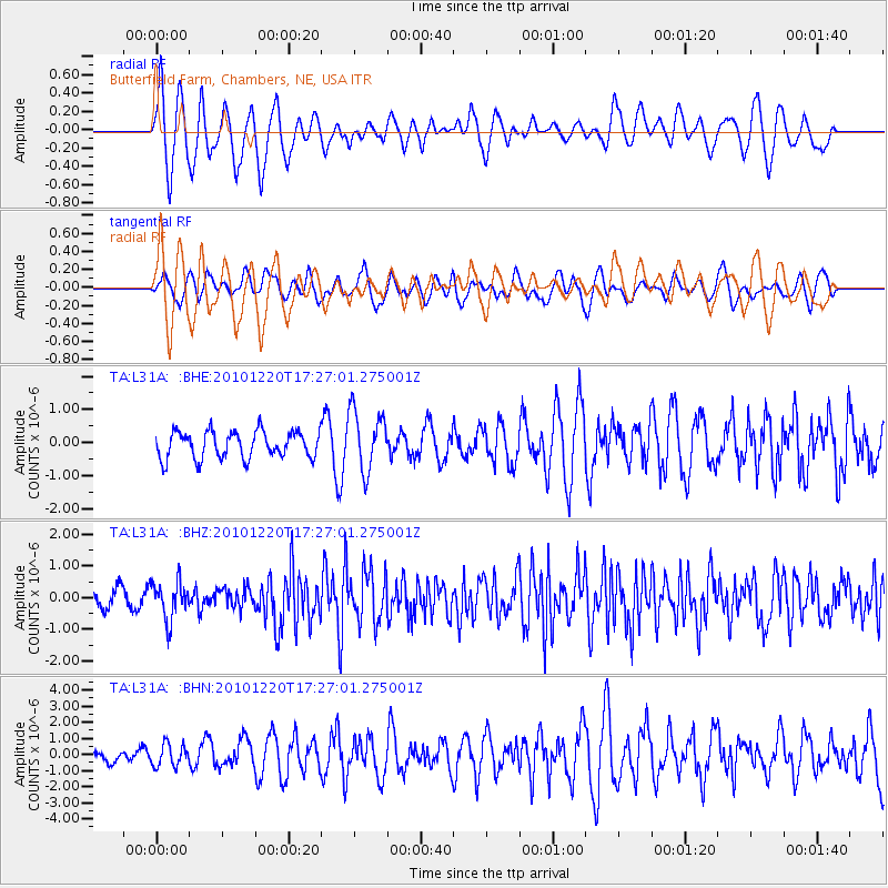
Signal To Noise
| Channel | StoN | STA | LTA |
| TA:L31A: :BHZ:20101220T17:27:01.275001Z | 2.781259 | 6.073496E-7 | 2.1837218E-7 |
| TA:L31A: :BHN:20101220T17:27:01.275001Z | 1.225416 | 6.8631385E-7 | 5.6006604E-7 |
| TA:L31A: :BHE:20101220T17:27:01.275001Z | 2.264624 | 9.2026403E-7 | 4.0636502E-7 |
| Arrivals |
| Ps | 7.0 SECOND |
| PpPs | 18 SECOND |
| PsPs/PpSs | 25 SECOND |


