You are here: Home > Network List > TA - USArray Transportable Network (new EarthScope stations) Stations List
> Station G32A Webster, SD, USA > Earthquake Result Viewer
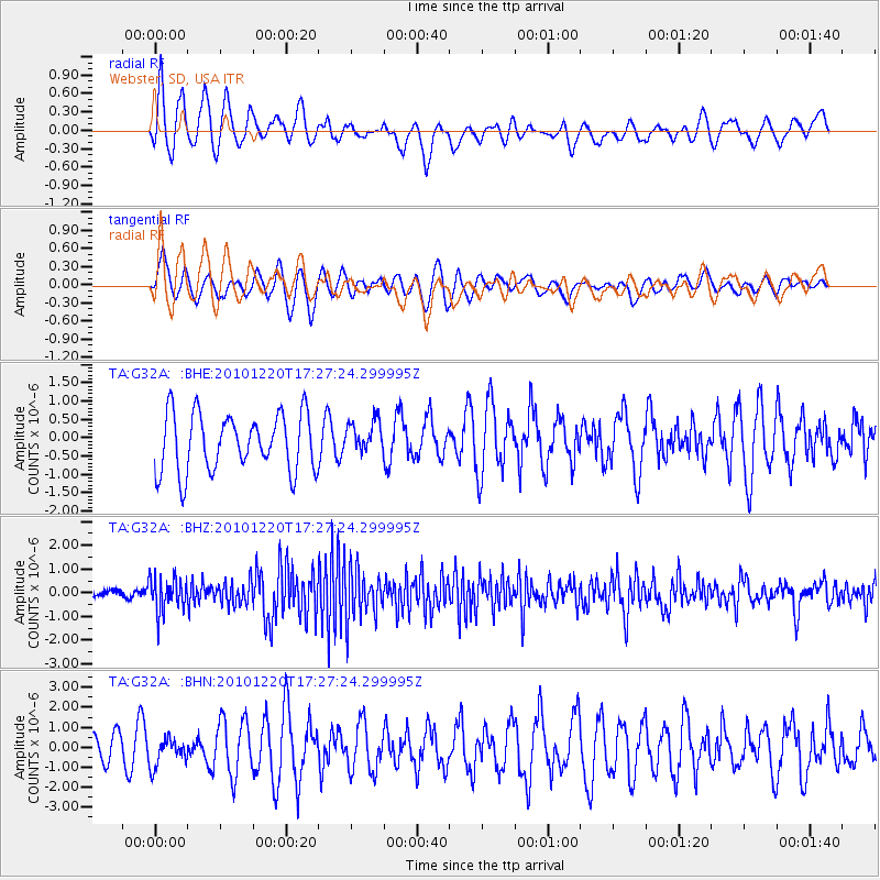
G32A Webster, SD, USA - Earthquake Result Viewer
*The percent match for this event was below the threshold and hence no stack was calculated.
| Earthquake location: |
Off Coast Of Central America |
| Earthquake latitude/longitude: |
13.0/-88.6 |
| Earthquake time(UTC): |
2010/12/20 (354) 17:21:26 GMT |
| Earthquake Depth: |
72 km |
| Earthquake Magnitude: |
5.5 MB, 5.7 MW, 5.7 MW |
| Earthquake Catalog/Contributor: |
WHDF/NEIC |
|
| Network: |
TA USArray Transportable Network (new EarthScope stations) |
| Station: |
G32A Webster, SD, USA |
| Lat/Lon: |
45.26 N/97.50 W |
| Elevation: |
566 m |
|
| Distance: |
33.0 deg |
| Az: |
348.487 deg |
| Baz: |
164.012 deg |
| Ray Param: |
$rayparam |
*The percent match for this event was below the threshold and hence was not used in the summary stack. |
|
| Radial Match: |
62.454304 % |
| Radial Bump: |
400 |
| Transverse Match: |
66.69949 % |
| Transverse Bump: |
400 |
| SOD ConfigId: |
343951 |
| Insert Time: |
2011-05-24 16:11:25.398 +0000 |
| GWidth: |
2.5 |
| Max Bumps: |
400 |
| Tol: |
0.001 |
|
Signal To Noise
| Channel | StoN | STA | LTA |
| TA:G32A: :BHZ:20101220T17:27:24.299995Z | 2.4738283 | 7.152218E-7 | 2.8911538E-7 |
| TA:G32A: :BHN:20101220T17:27:24.299995Z | 0.90002674 | 6.7507733E-7 | 7.5006363E-7 |
| TA:G32A: :BHE:20101220T17:27:24.299995Z | 0.57599 | 4.5294982E-7 | 7.863849E-7 |
| Arrivals |
| Ps | |
| PpPs | |
| PsPs/PpSs | |


