You are here: Home > Network List > TA - USArray Transportable Network (new EarthScope stations) Stations List
> Station C36A Pine Crest Fram, Angora, MN, USA > Earthquake Result Viewer
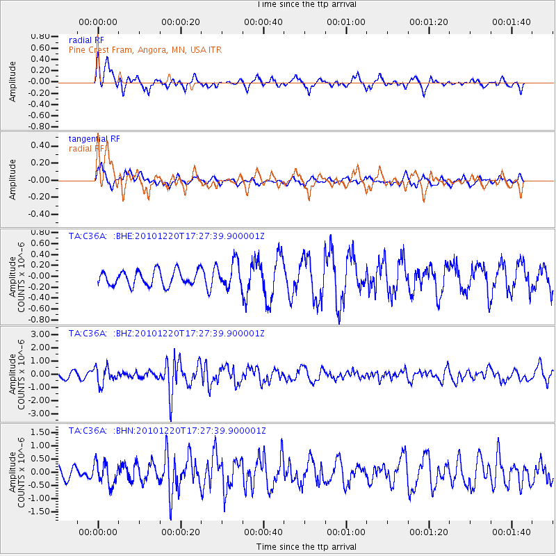
C36A Pine Crest Fram, Angora, MN, USA - Earthquake Result Viewer
*The percent match for this event was below the threshold and hence no stack was calculated.
| Earthquake location: |
Off Coast Of Central America |
| Earthquake latitude/longitude: |
13.0/-88.6 |
| Earthquake time(UTC): |
2010/12/20 (354) 17:21:26 GMT |
| Earthquake Depth: |
72 km |
| Earthquake Magnitude: |
5.5 MB, 5.7 MW, 5.7 MW |
| Earthquake Catalog/Contributor: |
WHDF/NEIC |
|
| Network: |
TA USArray Transportable Network (new EarthScope stations) |
| Station: |
C36A Pine Crest Fram, Angora, MN, USA |
| Lat/Lon: |
47.76 N/92.84 W |
| Elevation: |
410 m |
|
| Distance: |
34.8 deg |
| Az: |
355.039 deg |
| Baz: |
172.824 deg |
| Ray Param: |
$rayparam |
*The percent match for this event was below the threshold and hence was not used in the summary stack. |
|
| Radial Match: |
57.3313 % |
| Radial Bump: |
350 |
| Transverse Match: |
65.48354 % |
| Transverse Bump: |
342 |
| SOD ConfigId: |
343951 |
| Insert Time: |
2011-05-24 16:13:36.993 +0000 |
| GWidth: |
2.5 |
| Max Bumps: |
400 |
| Tol: |
0.001 |
|
Signal To Noise
| Channel | StoN | STA | LTA |
| TA:C36A: :BHZ:20101220T17:27:39.900001Z | 2.8629596 | 6.349125E-7 | 2.2176788E-7 |
| TA:C36A: :BHN:20101220T17:27:39.900001Z | 1.3416228 | 4.3103233E-7 | 3.2127681E-7 |
| TA:C36A: :BHE:20101220T17:27:39.900001Z | 1.7421024 | 2.3743532E-7 | 1.362924E-7 |
| Arrivals |
| Ps | |
| PpPs | |
| PsPs/PpSs | |


