You are here: Home > Network List > TA - USArray Transportable Network (new EarthScope stations) Stations List
> Station X43A Marvell, AR, USA > Earthquake Result Viewer
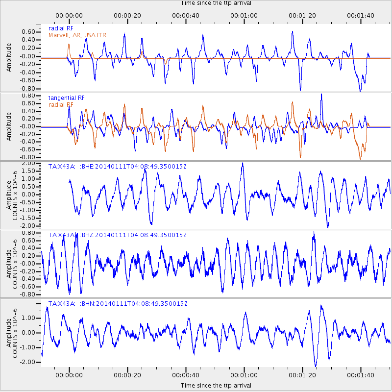
X43A Marvell, AR, USA - Earthquake Result Viewer
*The percent match for this event was below the threshold and hence no stack was calculated.
| Earthquake location: |
Eastern Sea Of Japan |
| Earthquake latitude/longitude: |
43.7/139.2 |
| Earthquake time(UTC): |
2014/01/11 (011) 03:56:48 GMT |
| Earthquake Depth: |
230 km |
| Earthquake Magnitude: |
5.0 MW |
| Earthquake Catalog/Contributor: |
ISC/ISC |
|
| Network: |
TA USArray Transportable Network (new EarthScope stations) |
| Station: |
X43A Marvell, AR, USA |
| Lat/Lon: |
34.52 N/90.88 W |
| Elevation: |
53 m |
|
| Distance: |
89.8 deg |
| Az: |
39.318 deg |
| Baz: |
326.16 deg |
| Ray Param: |
$rayparam |
*The percent match for this event was below the threshold and hence was not used in the summary stack. |
|
| Radial Match: |
44.808647 % |
| Radial Bump: |
400 |
| Transverse Match: |
54.170418 % |
| Transverse Bump: |
400 |
| SOD ConfigId: |
3390531 |
| Insert Time: |
2019-04-09 23:29:04.343 +0000 |
| GWidth: |
2.5 |
| Max Bumps: |
400 |
| Tol: |
0.001 |
|
Signal To Noise
| Channel | StoN | STA | LTA |
| TA:X43A: :BHZ:20140111T04:08:49.350015Z | 1.3265058 | 5.060269E-7 | 3.8147357E-7 |
| TA:X43A: :BHN:20140111T04:08:49.350015Z | 1.0433604 | 6.724395E-7 | 6.44494E-7 |
| TA:X43A: :BHE:20140111T04:08:49.350015Z | 1.3553336 | 8.0744E-7 | 5.9575007E-7 |
| Arrivals |
| Ps | |
| PpPs | |
| PsPs/PpSs | |


