You are here: Home > Network List > US - United States National Seismic Network Stations List
> Station DGMT Dagmar, Montana, USA > Earthquake Result Viewer
DGMT Dagmar, Montana, USA - Earthquake Result Viewer
*The percent match for this event was below the threshold and hence no stack was calculated.
| Earthquake location: |
Off Coast Of Central America |
| Earthquake latitude/longitude: |
13.0/-88.6 |
| Earthquake time(UTC): |
2010/12/20 (354) 17:21:26 GMT |
| Earthquake Depth: |
72 km |
| Earthquake Magnitude: |
5.5 MB, 5.7 MW, 5.7 MW |
| Earthquake Catalog/Contributor: |
WHDF/NEIC |
|
| Network: |
US United States National Seismic Network |
| Station: |
DGMT Dagmar, Montana, USA |
| Lat/Lon: |
48.47 N/104.20 W |
| Elevation: |
0.0 m |
|
| Distance: |
37.7 deg |
| Az: |
343.015 deg |
| Baz: |
154.668 deg |
| Ray Param: |
$rayparam |
*The percent match for this event was below the threshold and hence was not used in the summary stack. |
|
| Radial Match: |
43.60515 % |
| Radial Bump: |
400 |
| Transverse Match: |
53.984318 % |
| Transverse Bump: |
400 |
| SOD ConfigId: |
343951 |
| Insert Time: |
2011-05-24 16:20:19.128 +0000 |
| GWidth: |
2.5 |
| Max Bumps: |
400 |
| Tol: |
0.001 |
|
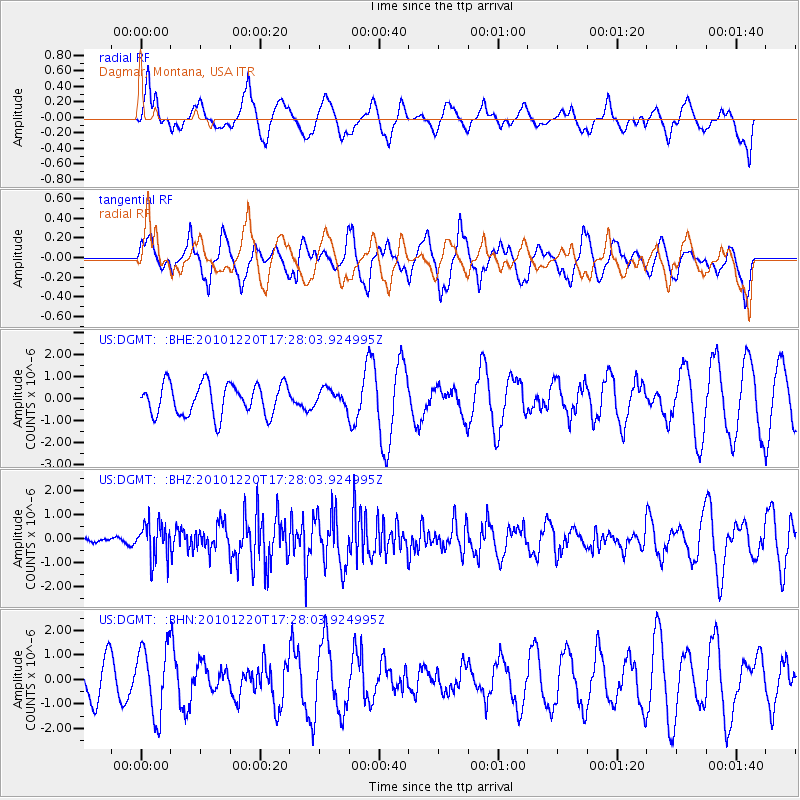
Signal To Noise
| Channel | StoN | STA | LTA |
| US:DGMT: :BHZ:20101220T17:28:03.924995Z | 2.709525 | 7.386586E-7 | 2.7261552E-7 |
| US:DGMT: :BHN:20101220T17:28:03.924995Z | 1.7122195 | 1.3926815E-6 | 8.133779E-7 |
| US:DGMT: :BHE:20101220T17:28:03.924995Z | 0.5451062 | 3.8645751E-7 | 7.089583E-7 |
| Arrivals |
| Ps | |
| PpPs | |
| PsPs/PpSs | |


