You are here: Home > Network List > CI - Caltech Regional Seismic Network Stations List
> Station LGU LGU, Camarillo, CA, USA > Earthquake Result Viewer
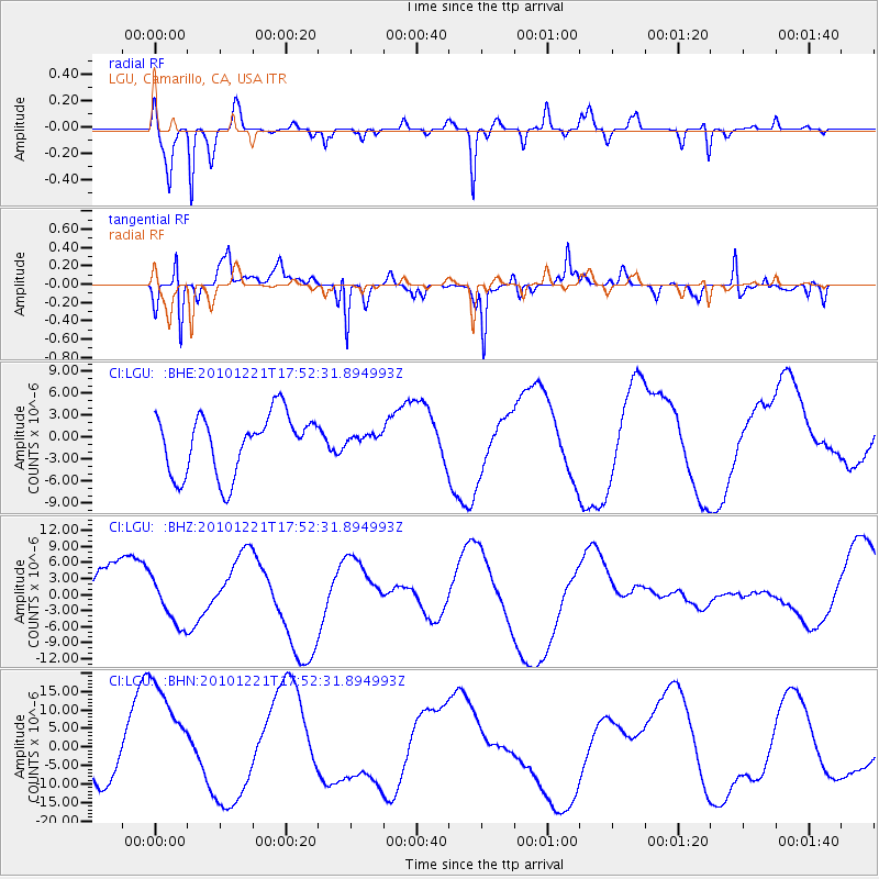
LGU LGU, Camarillo, CA, USA - Earthquake Result Viewer
*The percent match for this event was below the threshold and hence no stack was calculated.
| Earthquake location: |
Bonin Islands, Japan Region |
| Earthquake latitude/longitude: |
27.1/143.2 |
| Earthquake time(UTC): |
2010/12/21 (355) 17:40:47 GMT |
| Earthquake Depth: |
10 km |
| Earthquake Magnitude: |
5.5 MB |
| Earthquake Catalog/Contributor: |
WHDF/NEIC |
|
| Network: |
CI Caltech Regional Seismic Network |
| Station: |
LGU LGU, Camarillo, CA, USA |
| Lat/Lon: |
34.11 N/119.07 W |
| Elevation: |
416 m |
|
| Distance: |
81.2 deg |
| Az: |
56.31 deg |
| Baz: |
296.606 deg |
| Ray Param: |
$rayparam |
*The percent match for this event was below the threshold and hence was not used in the summary stack. |
|
| Radial Match: |
80.59399 % |
| Radial Bump: |
256 |
| Transverse Match: |
73.82483 % |
| Transverse Bump: |
325 |
| SOD ConfigId: |
343951 |
| Insert Time: |
2011-05-24 17:17:38.895 +0000 |
| GWidth: |
2.5 |
| Max Bumps: |
400 |
| Tol: |
0.001 |
|
Signal To Noise
| Channel | StoN | STA | LTA |
| CI:LGU: :BHZ:20101221T17:52:31.894993Z | 0.68534446 | 4.3954183E-6 | 6.4134433E-6 |
| CI:LGU: :BHN:20101221T17:52:31.894993Z | 3.7896605 | 1.5578538E-5 | 4.1108005E-6 |
| CI:LGU: :BHE:20101221T17:52:31.894993Z | 0.19266343 | 7.7837046E-7 | 4.040053E-6 |
| Arrivals |
| Ps | |
| PpPs | |
| PsPs/PpSs | |


