You are here: Home > Network List > TA - USArray Transportable Network (new EarthScope stations) Stations List
> Station 121A Cookes Peak, Deming, NM, USA > Earthquake Result Viewer
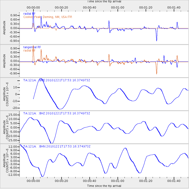
121A Cookes Peak, Deming, NM, USA - Earthquake Result Viewer
*The percent match for this event was below the threshold and hence no stack was calculated.
| Earthquake location: |
Bonin Islands, Japan Region |
| Earthquake latitude/longitude: |
27.1/143.2 |
| Earthquake time(UTC): |
2010/12/21 (355) 17:40:47 GMT |
| Earthquake Depth: |
10 km |
| Earthquake Magnitude: |
5.5 MB |
| Earthquake Catalog/Contributor: |
WHDF/NEIC |
|
| Network: |
TA USArray Transportable Network (new EarthScope stations) |
| Station: |
121A Cookes Peak, Deming, NM, USA |
| Lat/Lon: |
32.53 N/107.79 W |
| Elevation: |
1652 m |
|
| Distance: |
90.2 deg |
| Az: |
53.006 deg |
| Baz: |
302.538 deg |
| Ray Param: |
$rayparam |
*The percent match for this event was below the threshold and hence was not used in the summary stack. |
|
| Radial Match: |
59.10254 % |
| Radial Bump: |
299 |
| Transverse Match: |
59.312687 % |
| Transverse Bump: |
398 |
| SOD ConfigId: |
343951 |
| Insert Time: |
2011-05-24 17:28:32.394 +0000 |
| GWidth: |
2.5 |
| Max Bumps: |
400 |
| Tol: |
0.001 |
|
Signal To Noise
| Channel | StoN | STA | LTA |
| TA:121A: :BHZ:20101221T17:53:16.374973Z | 2.1643443 | 1.16360025E-5 | 5.376225E-6 |
| TA:121A: :BHN:20101221T17:53:16.374973Z | 0.71901995 | 6.1499313E-6 | 8.553214E-6 |
| TA:121A: :BHE:20101221T17:53:16.374973Z | 0.7157036 | 1.0689642E-5 | 1.493585E-5 |
| Arrivals |
| Ps | |
| PpPs | |
| PsPs/PpSs | |


