You are here: Home > Network List > TA - USArray Transportable Network (new EarthScope stations) Stations List
> Station S29A Ulysses, KS, USA > Earthquake Result Viewer
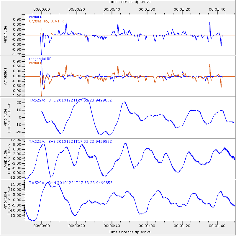
S29A Ulysses, KS, USA - Earthquake Result Viewer
*The percent match for this event was below the threshold and hence no stack was calculated.
| Earthquake location: |
Bonin Islands, Japan Region |
| Earthquake latitude/longitude: |
27.1/143.2 |
| Earthquake time(UTC): |
2010/12/21 (355) 17:40:47 GMT |
| Earthquake Depth: |
10 km |
| Earthquake Magnitude: |
5.5 MB |
| Earthquake Catalog/Contributor: |
WHDF/NEIC |
|
| Network: |
TA USArray Transportable Network (new EarthScope stations) |
| Station: |
S29A Ulysses, KS, USA |
| Lat/Lon: |
37.62 N/101.12 W |
| Elevation: |
931 m |
|
| Distance: |
91.8 deg |
| Az: |
45.73 deg |
| Baz: |
306.484 deg |
| Ray Param: |
$rayparam |
*The percent match for this event was below the threshold and hence was not used in the summary stack. |
|
| Radial Match: |
47.368324 % |
| Radial Bump: |
282 |
| Transverse Match: |
68.03878 % |
| Transverse Bump: |
400 |
| SOD ConfigId: |
343951 |
| Insert Time: |
2011-05-24 17:34:55.186 +0000 |
| GWidth: |
2.5 |
| Max Bumps: |
400 |
| Tol: |
0.001 |
|
Signal To Noise
| Channel | StoN | STA | LTA |
| TA:S29A: :BHZ:20101221T17:53:23.949985Z | 1.0245217 | 7.484159E-6 | 7.3050273E-6 |
| TA:S29A: :BHN:20101221T17:53:23.949985Z | 1.6916915 | 1.3889039E-5 | 8.210149E-6 |
| TA:S29A: :BHE:20101221T17:53:23.949985Z | 1.2226574 | 1.8666602E-5 | 1.5267238E-5 |
| Arrivals |
| Ps | |
| PpPs | |
| PsPs/PpSs | |


