You are here: Home > Network List > TA - USArray Transportable Network (new EarthScope stations) Stations List
> Station S30A Montezuma, KS, USA > Earthquake Result Viewer
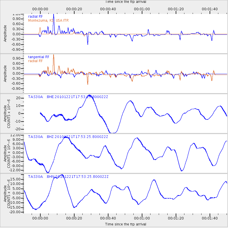
S30A Montezuma, KS, USA - Earthquake Result Viewer
*The percent match for this event was below the threshold and hence no stack was calculated.
| Earthquake location: |
Bonin Islands, Japan Region |
| Earthquake latitude/longitude: |
27.1/143.2 |
| Earthquake time(UTC): |
2010/12/21 (355) 17:40:47 GMT |
| Earthquake Depth: |
10 km |
| Earthquake Magnitude: |
5.5 MB |
| Earthquake Catalog/Contributor: |
WHDF/NEIC |
|
| Network: |
TA USArray Transportable Network (new EarthScope stations) |
| Station: |
S30A Montezuma, KS, USA |
| Lat/Lon: |
37.64 N/100.46 W |
| Elevation: |
853 m |
|
| Distance: |
92.2 deg |
| Az: |
45.403 deg |
| Baz: |
306.893 deg |
| Ray Param: |
$rayparam |
*The percent match for this event was below the threshold and hence was not used in the summary stack. |
|
| Radial Match: |
61.45441 % |
| Radial Bump: |
336 |
| Transverse Match: |
61.190037 % |
| Transverse Bump: |
400 |
| SOD ConfigId: |
343951 |
| Insert Time: |
2011-05-24 17:35:29.283 +0000 |
| GWidth: |
2.5 |
| Max Bumps: |
400 |
| Tol: |
0.001 |
|
Signal To Noise
| Channel | StoN | STA | LTA |
| TA:S30A: :BHZ:20101221T17:53:25.800022Z | 1.7169428 | 1.1151954E-5 | 6.495239E-6 |
| TA:S30A: :BHN:20101221T17:53:25.800022Z | 2.0180728 | 1.1581137E-5 | 5.7387115E-6 |
| TA:S30A: :BHE:20101221T17:53:25.800022Z | 3.9600286 | 1.8927758E-5 | 4.779702E-6 |
| Arrivals |
| Ps | |
| PpPs | |
| PsPs/PpSs | |


