You are here: Home > Network List > TA - USArray Transportable Network (new EarthScope stations) Stations List
> Station R31A Burdett, KS, USA > Earthquake Result Viewer
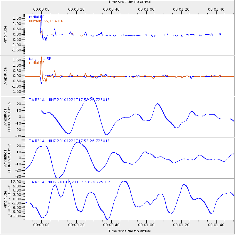
R31A Burdett, KS, USA - Earthquake Result Viewer
*The percent match for this event was below the threshold and hence no stack was calculated.
| Earthquake location: |
Bonin Islands, Japan Region |
| Earthquake latitude/longitude: |
27.1/143.2 |
| Earthquake time(UTC): |
2010/12/21 (355) 17:40:47 GMT |
| Earthquake Depth: |
10 km |
| Earthquake Magnitude: |
5.5 MB |
| Earthquake Catalog/Contributor: |
WHDF/NEIC |
|
| Network: |
TA USArray Transportable Network (new EarthScope stations) |
| Station: |
R31A Burdett, KS, USA |
| Lat/Lon: |
38.29 N/99.53 W |
| Elevation: |
667 m |
|
| Distance: |
92.4 deg |
| Az: |
44.439 deg |
| Baz: |
307.506 deg |
| Ray Param: |
$rayparam |
*The percent match for this event was below the threshold and hence was not used in the summary stack. |
|
| Radial Match: |
45.353004 % |
| Radial Bump: |
400 |
| Transverse Match: |
74.91875 % |
| Transverse Bump: |
400 |
| SOD ConfigId: |
343951 |
| Insert Time: |
2011-05-24 17:36:48.827 +0000 |
| GWidth: |
2.5 |
| Max Bumps: |
400 |
| Tol: |
0.001 |
|
Signal To Noise
| Channel | StoN | STA | LTA |
| TA:R31A: :BHZ:20101221T17:53:26.72501Z | 1.8172694 | 2.03298E-5 | 1.1187005E-5 |
| TA:R31A: :BHN:20101221T17:53:26.72501Z | 2.7131464 | 1.14420645E-5 | 4.2172674E-6 |
| TA:R31A: :BHE:20101221T17:53:26.72501Z | 1.5042431 | 2.0731031E-5 | 1.3781702E-5 |
| Arrivals |
| Ps | |
| PpPs | |
| PsPs/PpSs | |


