You are here: Home > Network List > TA - USArray Transportable Network (new EarthScope stations) Stations List
> Station N35A Tabor, IA, USA > Earthquake Result Viewer
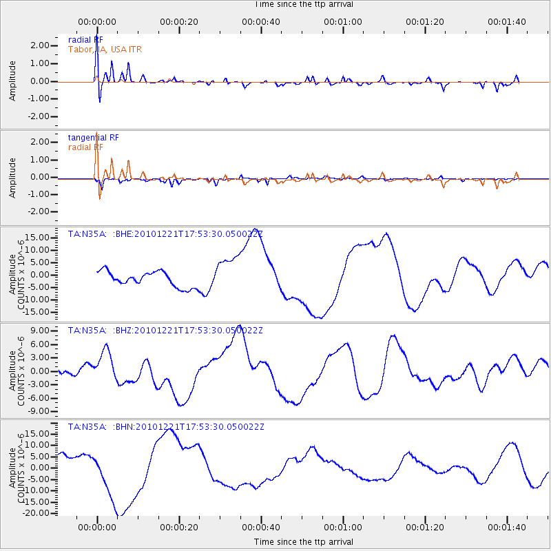
N35A Tabor, IA, USA - Earthquake Result Viewer
*The percent match for this event was below the threshold and hence no stack was calculated.
| Earthquake location: |
Bonin Islands, Japan Region |
| Earthquake latitude/longitude: |
27.1/143.2 |
| Earthquake time(UTC): |
2010/12/21 (355) 17:40:47 GMT |
| Earthquake Depth: |
10 km |
| Earthquake Magnitude: |
5.5 MB |
| Earthquake Catalog/Contributor: |
WHDF/NEIC |
|
| Network: |
TA USArray Transportable Network (new EarthScope stations) |
| Station: |
N35A Tabor, IA, USA |
| Lat/Lon: |
40.86 N/95.64 W |
| Elevation: |
353 m |
|
| Distance: |
93.1 deg |
| Az: |
40.551 deg |
| Baz: |
310.16 deg |
| Ray Param: |
$rayparam |
*The percent match for this event was below the threshold and hence was not used in the summary stack. |
|
| Radial Match: |
57.43828 % |
| Radial Bump: |
363 |
| Transverse Match: |
47.385963 % |
| Transverse Bump: |
314 |
| SOD ConfigId: |
346175 |
| Insert Time: |
2011-05-24 21:02:29.925 +0000 |
| GWidth: |
2.5 |
| Max Bumps: |
400 |
| Tol: |
0.001 |
|
Signal To Noise
| Channel | StoN | STA | LTA |
| TA:N35A: :BHZ:20101221T17:53:30.050022Z | 1.4141926 | 3.836426E-6 | 2.7128033E-6 |
| TA:N35A: :BHN:20101221T17:53:30.050022Z | 2.902644 | 1.0531291E-5 | 3.6281722E-6 |
| TA:N35A: :BHE:20101221T17:53:30.050022Z | 2.5380723 | 7.775515E-6 | 3.0635513E-6 |
| Arrivals |
| Ps | |
| PpPs | |
| PsPs/PpSs | |


