You are here: Home > Network List > TA - USArray Transportable Network (new EarthScope stations) Stations List
> Station U36A Oologah, OK, USA > Earthquake Result Viewer
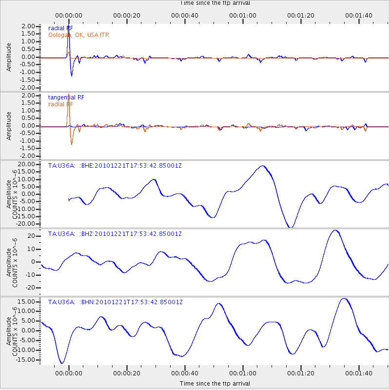
U36A Oologah, OK, USA - Earthquake Result Viewer
*The percent match for this event was below the threshold and hence no stack was calculated.
| Earthquake location: |
Bonin Islands, Japan Region |
| Earthquake latitude/longitude: |
27.1/143.2 |
| Earthquake time(UTC): |
2010/12/21 (355) 17:40:47 GMT |
| Earthquake Depth: |
10 km |
| Earthquake Magnitude: |
5.5 MB |
| Earthquake Catalog/Contributor: |
WHDF/NEIC |
|
| Network: |
TA USArray Transportable Network (new EarthScope stations) |
| Station: |
U36A Oologah, OK, USA |
| Lat/Lon: |
36.39 N/95.73 W |
| Elevation: |
187 m |
|
| Distance: |
95.9 deg |
| Az: |
44.025 deg |
| Baz: |
309.828 deg |
| Ray Param: |
$rayparam |
*The percent match for this event was below the threshold and hence was not used in the summary stack. |
|
| Radial Match: |
38.48495 % |
| Radial Bump: |
400 |
| Transverse Match: |
34.170208 % |
| Transverse Bump: |
400 |
| SOD ConfigId: |
346175 |
| Insert Time: |
2011-05-24 21:11:07.898 +0000 |
| GWidth: |
2.5 |
| Max Bumps: |
400 |
| Tol: |
0.001 |
|
Signal To Noise
| Channel | StoN | STA | LTA |
| TA:U36A: :BHZ:20101221T17:53:42.85001Z | 2.0951395 | 6.599255E-6 | 3.1497925E-6 |
| TA:U36A: :BHN:20101221T17:53:42.85001Z | 1.3442584 | 5.30435E-6 | 3.94593E-6 |
| TA:U36A: :BHE:20101221T17:53:42.85001Z | 1.7890075 | 5.8018427E-6 | 3.243051E-6 |
| Arrivals |
| Ps | |
| PpPs | |
| PsPs/PpSs | |


