You are here: Home > Network List > TA - USArray Transportable Network (new EarthScope stations) Stations List
> Station K32A Verdigre, NE, USA > Earthquake Result Viewer
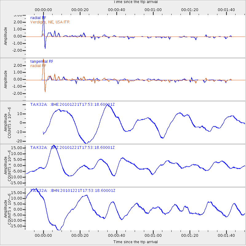
K32A Verdigre, NE, USA - Earthquake Result Viewer
*The percent match for this event was below the threshold and hence no stack was calculated.
| Earthquake location: |
Bonin Islands, Japan Region |
| Earthquake latitude/longitude: |
27.1/143.2 |
| Earthquake time(UTC): |
2010/12/21 (355) 17:40:47 GMT |
| Earthquake Depth: |
10 km |
| Earthquake Magnitude: |
5.5 MB |
| Earthquake Catalog/Contributor: |
WHDF/NEIC |
|
| Network: |
TA USArray Transportable Network (new EarthScope stations) |
| Station: |
K32A Verdigre, NE, USA |
| Lat/Lon: |
42.66 N/97.97 W |
| Elevation: |
512 m |
|
| Distance: |
90.6 deg |
| Az: |
40.269 deg |
| Baz: |
308.623 deg |
| Ray Param: |
$rayparam |
*The percent match for this event was below the threshold and hence was not used in the summary stack. |
|
| Radial Match: |
67.54672 % |
| Radial Bump: |
400 |
| Transverse Match: |
72.82754 % |
| Transverse Bump: |
310 |
| SOD ConfigId: |
346175 |
| Insert Time: |
2011-05-24 21:11:52.488 +0000 |
| GWidth: |
2.5 |
| Max Bumps: |
400 |
| Tol: |
0.001 |
|
Signal To Noise
| Channel | StoN | STA | LTA |
| TA:K32A: :BHZ:20101221T17:53:18.60001Z | 2.0336626 | 8.573967E-6 | 4.2160223E-6 |
| TA:K32A: :BHN:20101221T17:53:18.60001Z | 0.92992723 | 9.561988E-6 | 1.02825115E-5 |
| TA:K32A: :BHE:20101221T17:53:18.60001Z | 0.8821961 | 1.1333971E-5 | 1.284745E-5 |
| Arrivals |
| Ps | |
| PpPs | |
| PsPs/PpSs | |


