You are here: Home > Network List > TA - USArray Transportable Network (new EarthScope stations) Stations List
> Station K33A Hardington, NE, USA > Earthquake Result Viewer
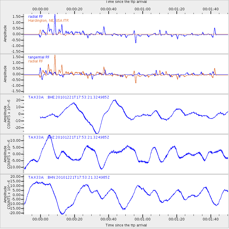
K33A Hardington, NE, USA - Earthquake Result Viewer
*The percent match for this event was below the threshold and hence no stack was calculated.
| Earthquake location: |
Bonin Islands, Japan Region |
| Earthquake latitude/longitude: |
27.1/143.2 |
| Earthquake time(UTC): |
2010/12/21 (355) 17:40:47 GMT |
| Earthquake Depth: |
10 km |
| Earthquake Magnitude: |
5.5 MB |
| Earthquake Catalog/Contributor: |
WHDF/NEIC |
|
| Network: |
TA USArray Transportable Network (new EarthScope stations) |
| Station: |
K33A Hardington, NE, USA |
| Lat/Lon: |
42.61 N/97.00 W |
| Elevation: |
507 m |
|
| Distance: |
91.2 deg |
| Az: |
39.861 deg |
| Baz: |
309.285 deg |
| Ray Param: |
$rayparam |
*The percent match for this event was below the threshold and hence was not used in the summary stack. |
|
| Radial Match: |
77.28734 % |
| Radial Bump: |
365 |
| Transverse Match: |
66.500145 % |
| Transverse Bump: |
400 |
| SOD ConfigId: |
346175 |
| Insert Time: |
2011-05-24 21:12:17.834 +0000 |
| GWidth: |
2.5 |
| Max Bumps: |
400 |
| Tol: |
0.001 |
|
Signal To Noise
| Channel | StoN | STA | LTA |
| TA:K33A: :BHZ:20101221T17:53:21.324985Z | 1.2999939 | 8.239124E-6 | 6.3378175E-6 |
| TA:K33A: :BHN:20101221T17:53:21.324985Z | 1.5089475 | 1.5239638E-5 | 1.0099515E-5 |
| TA:K33A: :BHE:20101221T17:53:21.324985Z | 3.7973368 | 2.6186892E-5 | 6.896121E-6 |
| Arrivals |
| Ps | |
| PpPs | |
| PsPs/PpSs | |


