You are here: Home > Network List > TA - USArray Transportable Network (new EarthScope stations) Stations List
> Station I32A Karley and Nick, Howard, SD, USA > Earthquake Result Viewer
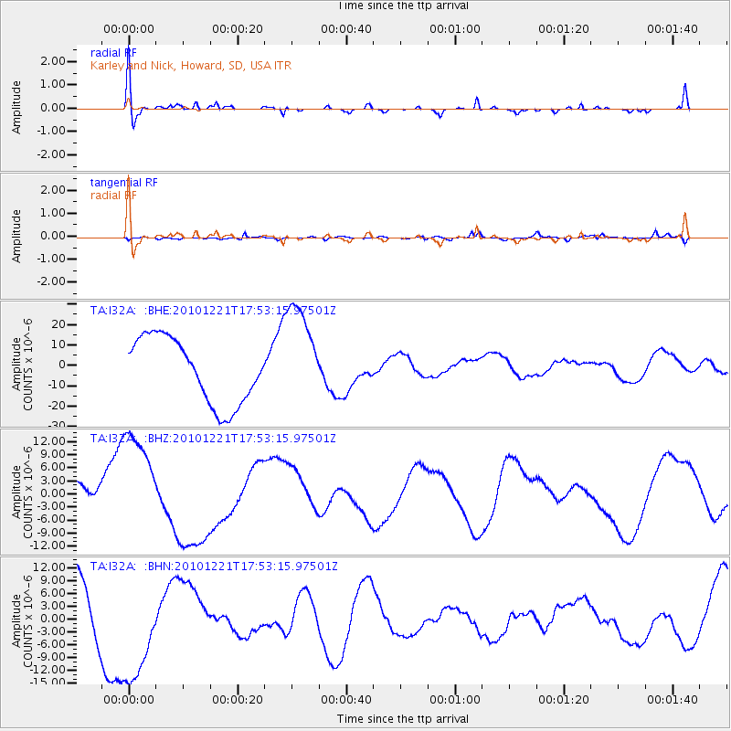
I32A Karley and Nick, Howard, SD, USA - Earthquake Result Viewer
*The percent match for this event was below the threshold and hence no stack was calculated.
| Earthquake location: |
Bonin Islands, Japan Region |
| Earthquake latitude/longitude: |
27.1/143.2 |
| Earthquake time(UTC): |
2010/12/21 (355) 17:40:47 GMT |
| Earthquake Depth: |
10 km |
| Earthquake Magnitude: |
5.5 MB |
| Earthquake Catalog/Contributor: |
WHDF/NEIC |
|
| Network: |
TA USArray Transportable Network (new EarthScope stations) |
| Station: |
I32A Karley and Nick, Howard, SD, USA |
| Lat/Lon: |
44.03 N/97.46 W |
| Elevation: |
493 m |
|
| Distance: |
90.1 deg |
| Az: |
38.971 deg |
| Baz: |
308.978 deg |
| Ray Param: |
$rayparam |
*The percent match for this event was below the threshold and hence was not used in the summary stack. |
|
| Radial Match: |
44.383972 % |
| Radial Bump: |
390 |
| Transverse Match: |
49.09161 % |
| Transverse Bump: |
400 |
| SOD ConfigId: |
346175 |
| Insert Time: |
2011-05-24 21:13:59.678 +0000 |
| GWidth: |
2.5 |
| Max Bumps: |
400 |
| Tol: |
0.001 |
|
Signal To Noise
| Channel | StoN | STA | LTA |
| TA:I32A: :BHZ:20101221T17:53:15.97501Z | 3.9129198 | 1.278317E-5 | 3.2669136E-6 |
| TA:I32A: :BHN:20101221T17:53:15.97501Z | 1.2429924 | 1.2966615E-5 | 1.0431773E-5 |
| TA:I32A: :BHE:20101221T17:53:15.97501Z | 1.6016941 | 2.5557752E-5 | 1.59567E-5 |
| Arrivals |
| Ps | |
| PpPs | |
| PsPs/PpSs | |


