You are here: Home > Network List > TA - USArray Transportable Network (new EarthScope stations) Stations List
> Station D33A AnnSam, Waubun, MN, USA > Earthquake Result Viewer
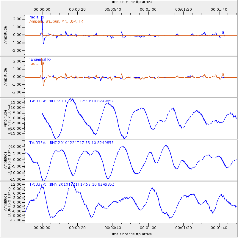
D33A AnnSam, Waubun, MN, USA - Earthquake Result Viewer
*The percent match for this event was below the threshold and hence no stack was calculated.
| Earthquake location: |
Bonin Islands, Japan Region |
| Earthquake latitude/longitude: |
27.1/143.2 |
| Earthquake time(UTC): |
2010/12/21 (355) 17:40:47 GMT |
| Earthquake Depth: |
10 km |
| Earthquake Magnitude: |
5.5 MB |
| Earthquake Catalog/Contributor: |
WHDF/NEIC |
|
| Network: |
TA USArray Transportable Network (new EarthScope stations) |
| Station: |
D33A AnnSam, Waubun, MN, USA |
| Lat/Lon: |
47.14 N/95.84 W |
| Elevation: |
466 m |
|
| Distance: |
89.0 deg |
| Az: |
35.846 deg |
| Baz: |
310.106 deg |
| Ray Param: |
$rayparam |
*The percent match for this event was below the threshold and hence was not used in the summary stack. |
|
| Radial Match: |
54.21209 % |
| Radial Bump: |
400 |
| Transverse Match: |
57.182632 % |
| Transverse Bump: |
325 |
| SOD ConfigId: |
346175 |
| Insert Time: |
2011-05-24 21:21:11.504 +0000 |
| GWidth: |
2.5 |
| Max Bumps: |
400 |
| Tol: |
0.001 |
|
Signal To Noise
| Channel | StoN | STA | LTA |
| TA:D33A: :BHZ:20101221T17:53:10.824985Z | 3.1311667 | 1.3995336E-5 | 4.4696876E-6 |
| TA:D33A: :BHN:20101221T17:53:10.824985Z | 0.93182147 | 7.5470357E-6 | 8.099229E-6 |
| TA:D33A: :BHE:20101221T17:53:10.824985Z | 0.8756743 | 1.0383351E-5 | 1.1857549E-5 |
| Arrivals |
| Ps | |
| PpPs | |
| PsPs/PpSs | |


