You are here: Home > Network List > US - United States National Seismic Network Stations List
> Station SDCO Great Sand Dunes National Park, Colorado, USA > Earthquake Result Viewer
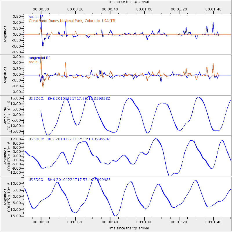
SDCO Great Sand Dunes National Park, Colorado, USA - Earthquake Result Viewer
*The percent match for this event was below the threshold and hence no stack was calculated.
| Earthquake location: |
Bonin Islands, Japan Region |
| Earthquake latitude/longitude: |
27.1/143.2 |
| Earthquake time(UTC): |
2010/12/21 (355) 17:40:47 GMT |
| Earthquake Depth: |
10 km |
| Earthquake Magnitude: |
5.5 MB |
| Earthquake Catalog/Contributor: |
WHDF/NEIC |
|
| Network: |
US United States National Seismic Network |
| Station: |
SDCO Great Sand Dunes National Park, Colorado, USA |
| Lat/Lon: |
37.75 N/105.50 W |
| Elevation: |
2569 m |
|
| Distance: |
88.9 deg |
| Az: |
47.629 deg |
| Baz: |
303.804 deg |
| Ray Param: |
$rayparam |
*The percent match for this event was below the threshold and hence was not used in the summary stack. |
|
| Radial Match: |
37.093365 % |
| Radial Bump: |
288 |
| Transverse Match: |
69.80223 % |
| Transverse Bump: |
400 |
| SOD ConfigId: |
346175 |
| Insert Time: |
2011-05-24 21:36:11.183 +0000 |
| GWidth: |
2.5 |
| Max Bumps: |
400 |
| Tol: |
0.001 |
|
Signal To Noise
| Channel | StoN | STA | LTA |
| US:SDCO: :BHZ:20101221T17:53:10.399998Z | 2.542417 | 9.739492E-6 | 3.8308003E-6 |
| US:SDCO: :BHN:20101221T17:53:10.399998Z | 0.6267659 | 2.8419483E-6 | 4.534306E-6 |
| US:SDCO: :BHE:20101221T17:53:10.399998Z | 1.1775863 | 1.17783275E-5 | 1.0002093E-5 |
| Arrivals |
| Ps | |
| PpPs | |
| PsPs/PpSs | |


