You are here: Home > Network List > US - United States National Seismic Network Stations List
> Station MNTX Cornudas Mountains, Texas, USA > Earthquake Result Viewer
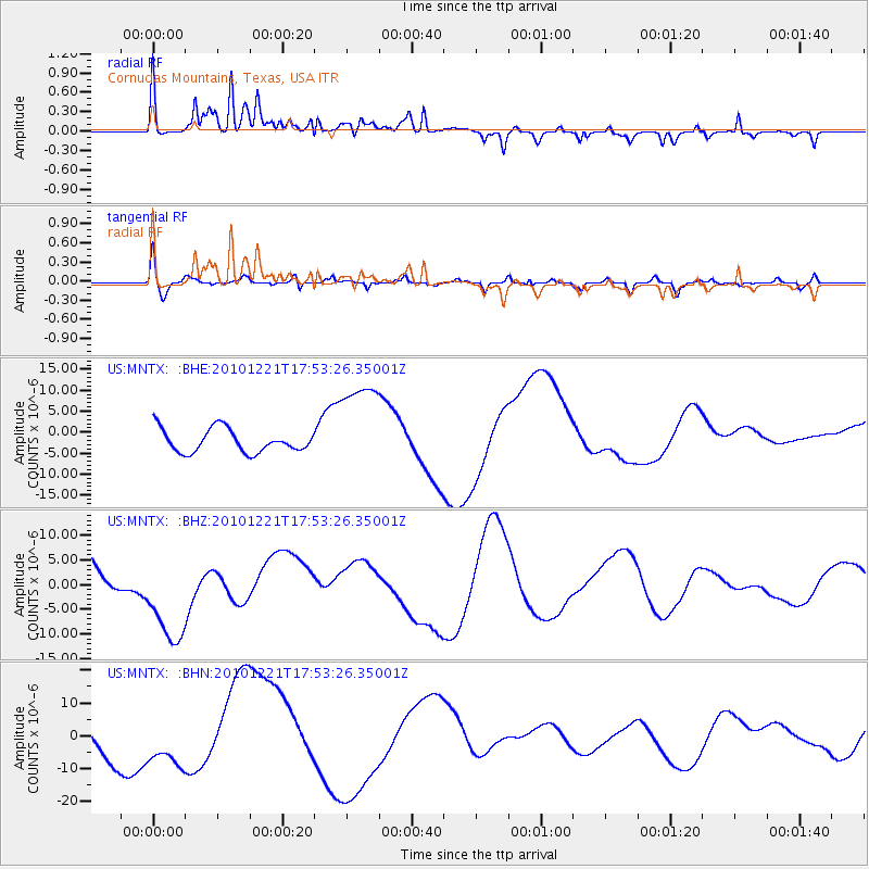
MNTX Cornudas Mountains, Texas, USA - Earthquake Result Viewer
*The percent match for this event was below the threshold and hence no stack was calculated.
| Earthquake location: |
Bonin Islands, Japan Region |
| Earthquake latitude/longitude: |
27.1/143.2 |
| Earthquake time(UTC): |
2010/12/21 (355) 17:40:47 GMT |
| Earthquake Depth: |
10 km |
| Earthquake Magnitude: |
5.5 MB |
| Earthquake Catalog/Contributor: |
WHDF/NEIC |
|
| Network: |
US United States National Seismic Network |
| Station: |
MNTX Cornudas Mountains, Texas, USA |
| Lat/Lon: |
31.70 N/105.38 W |
| Elevation: |
404 m |
|
| Distance: |
92.3 deg |
| Az: |
52.586 deg |
| Baz: |
303.819 deg |
| Ray Param: |
$rayparam |
*The percent match for this event was below the threshold and hence was not used in the summary stack. |
|
| Radial Match: |
39.78791 % |
| Radial Bump: |
400 |
| Transverse Match: |
35.723152 % |
| Transverse Bump: |
400 |
| SOD ConfigId: |
346175 |
| Insert Time: |
2011-05-24 21:36:24.563 +0000 |
| GWidth: |
2.5 |
| Max Bumps: |
400 |
| Tol: |
0.001 |
|
Signal To Noise
| Channel | StoN | STA | LTA |
| US:MNTX: :BHZ:20101221T17:53:26.35001Z | 3.497189 | 1.0114341E-5 | 2.8921345E-6 |
| US:MNTX: :BHN:20101221T17:53:26.35001Z | 1.3889246 | 8.50308E-6 | 6.1220603E-6 |
| US:MNTX: :BHE:20101221T17:53:26.35001Z | 4.2313824 | 1.168063E-5 | 2.760476E-6 |
| Arrivals |
| Ps | |
| PpPs | |
| PsPs/PpSs | |


