You are here: Home > Network List > US - United States National Seismic Network Stations List
> Station AMTX Amarillo, Texas, USA > Earthquake Result Viewer
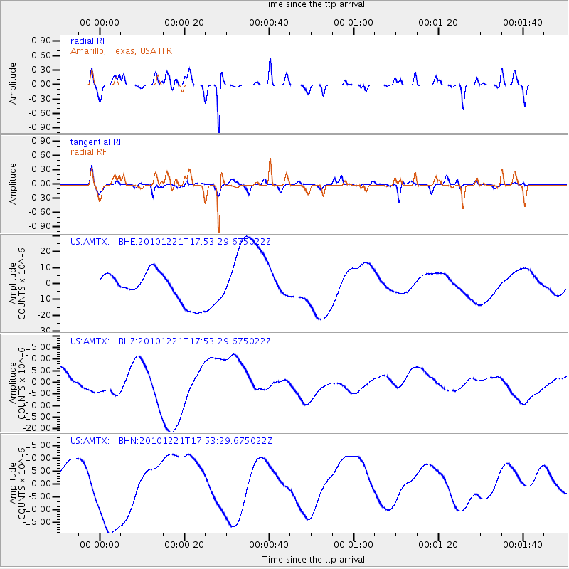
AMTX Amarillo, Texas, USA - Earthquake Result Viewer
*The percent match for this event was below the threshold and hence no stack was calculated.
| Earthquake location: |
Bonin Islands, Japan Region |
| Earthquake latitude/longitude: |
27.1/143.2 |
| Earthquake time(UTC): |
2010/12/21 (355) 17:40:47 GMT |
| Earthquake Depth: |
10 km |
| Earthquake Magnitude: |
5.5 MB |
| Earthquake Catalog/Contributor: |
WHDF/NEIC |
|
| Network: |
US United States National Seismic Network |
| Station: |
AMTX Amarillo, Texas, USA |
| Lat/Lon: |
34.53 N/101.41 W |
| Elevation: |
1010 m |
|
| Distance: |
93.4 deg |
| Az: |
48.356 deg |
| Baz: |
306.193 deg |
| Ray Param: |
$rayparam |
*The percent match for this event was below the threshold and hence was not used in the summary stack. |
|
| Radial Match: |
58.780872 % |
| Radial Bump: |
286 |
| Transverse Match: |
54.89454 % |
| Transverse Bump: |
400 |
| SOD ConfigId: |
346175 |
| Insert Time: |
2011-05-24 21:37:19.137 +0000 |
| GWidth: |
2.5 |
| Max Bumps: |
400 |
| Tol: |
0.001 |
|
Signal To Noise
| Channel | StoN | STA | LTA |
| US:AMTX: :BHZ:20101221T17:53:29.675022Z | 0.6777691 | 4.637174E-6 | 6.841819E-6 |
| US:AMTX: :BHN:20101221T17:53:29.675022Z | 4.0416107 | 1.7172115E-5 | 4.248829E-6 |
| US:AMTX: :BHE:20101221T17:53:29.675022Z | 2.756754 | 2.7037204E-5 | 9.807623E-6 |
| Arrivals |
| Ps | |
| PpPs | |
| PsPs/PpSs | |


