You are here: Home > Network List > CI - Caltech Regional Seismic Network Stations List
> Station OSI Osito Adit, California, USA > Earthquake Result Viewer
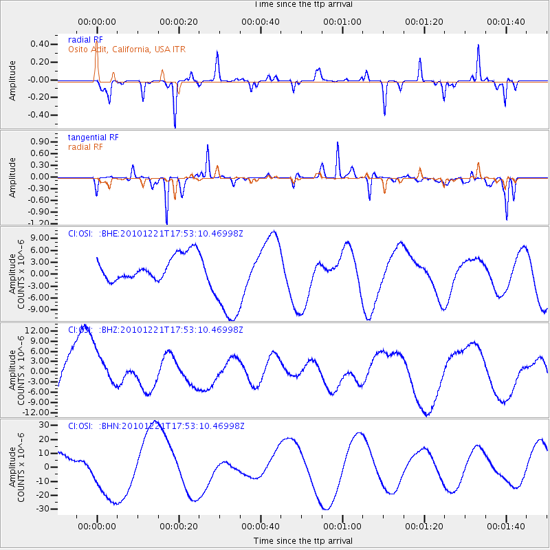
OSI Osito Adit, California, USA - Earthquake Result Viewer
*The percent match for this event was below the threshold and hence no stack was calculated.
| Earthquake location: |
Bonin Islands, Japan Region |
| Earthquake latitude/longitude: |
27.1/143.3 |
| Earthquake time(UTC): |
2010/12/21 (355) 17:41:25 GMT |
| Earthquake Depth: |
7.6 km |
| Earthquake Magnitude: |
5.5 MB |
| Earthquake Catalog/Contributor: |
WHDF/NEIC |
|
| Network: |
CI Caltech Regional Seismic Network |
| Station: |
OSI Osito Adit, California, USA |
| Lat/Lon: |
34.61 N/118.72 W |
| Elevation: |
706 m |
|
| Distance: |
81.1 deg |
| Az: |
55.76 deg |
| Baz: |
296.662 deg |
| Ray Param: |
$rayparam |
*The percent match for this event was below the threshold and hence was not used in the summary stack. |
|
| Radial Match: |
62.671307 % |
| Radial Bump: |
203 |
| Transverse Match: |
65.30742 % |
| Transverse Bump: |
226 |
| SOD ConfigId: |
346175 |
| Insert Time: |
2011-05-24 21:50:39.470 +0000 |
| GWidth: |
2.5 |
| Max Bumps: |
400 |
| Tol: |
0.001 |
|
Signal To Noise
| Channel | StoN | STA | LTA |
| CI:OSI: :BHZ:20101221T17:53:10.46998Z | 0.6421536 | 5.291205E-6 | 8.239781E-6 |
| CI:OSI: :BHN:20101221T17:53:10.46998Z | 4.3083715 | 2.1264E-5 | 4.935508E-6 |
| CI:OSI: :BHE:20101221T17:53:10.46998Z | 3.716797 | 1.1198762E-5 | 3.013014E-6 |
| Arrivals |
| Ps | |
| PpPs | |
| PsPs/PpSs | |


