You are here: Home > Network List > CI - Caltech Regional Seismic Network Stations List
> Station TUQ Turquiose Mountain, Baker, CA, USA > Earthquake Result Viewer
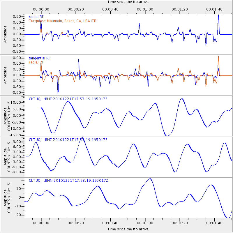
TUQ Turquiose Mountain, Baker, CA, USA - Earthquake Result Viewer
*The percent match for this event was below the threshold and hence no stack was calculated.
| Earthquake location: |
Bonin Islands, Japan Region |
| Earthquake latitude/longitude: |
27.1/143.3 |
| Earthquake time(UTC): |
2010/12/21 (355) 17:41:25 GMT |
| Earthquake Depth: |
7.6 km |
| Earthquake Magnitude: |
5.5 MB |
| Earthquake Catalog/Contributor: |
WHDF/NEIC |
|
| Network: |
CI Caltech Regional Seismic Network |
| Station: |
TUQ Turquiose Mountain, Baker, CA, USA |
| Lat/Lon: |
35.44 N/115.92 W |
| Elevation: |
1350 m |
|
| Distance: |
82.8 deg |
| Az: |
53.959 deg |
| Baz: |
298.011 deg |
| Ray Param: |
$rayparam |
*The percent match for this event was below the threshold and hence was not used in the summary stack. |
|
| Radial Match: |
54.456326 % |
| Radial Bump: |
400 |
| Transverse Match: |
83.97068 % |
| Transverse Bump: |
297 |
| SOD ConfigId: |
346175 |
| Insert Time: |
2011-05-24 21:55:00.848 +0000 |
| GWidth: |
2.5 |
| Max Bumps: |
400 |
| Tol: |
0.001 |
|
Signal To Noise
| Channel | StoN | STA | LTA |
| CI:TUQ: :BHZ:20101221T17:53:19.195017Z | 1.1490589 | 3.890738E-6 | 3.3860208E-6 |
| CI:TUQ: :BHN:20101221T17:53:19.195017Z | 1.5425406 | 8.241508E-6 | 5.3428143E-6 |
| CI:TUQ: :BHE:20101221T17:53:19.195017Z | 0.39395416 | 2.9104076E-6 | 7.387681E-6 |
| Arrivals |
| Ps | |
| PpPs | |
| PsPs/PpSs | |


