You are here: Home > Network List > TA - USArray Transportable Network (new EarthScope stations) Stations List
> Station 531A Rocksprings, TX, USA > Earthquake Result Viewer
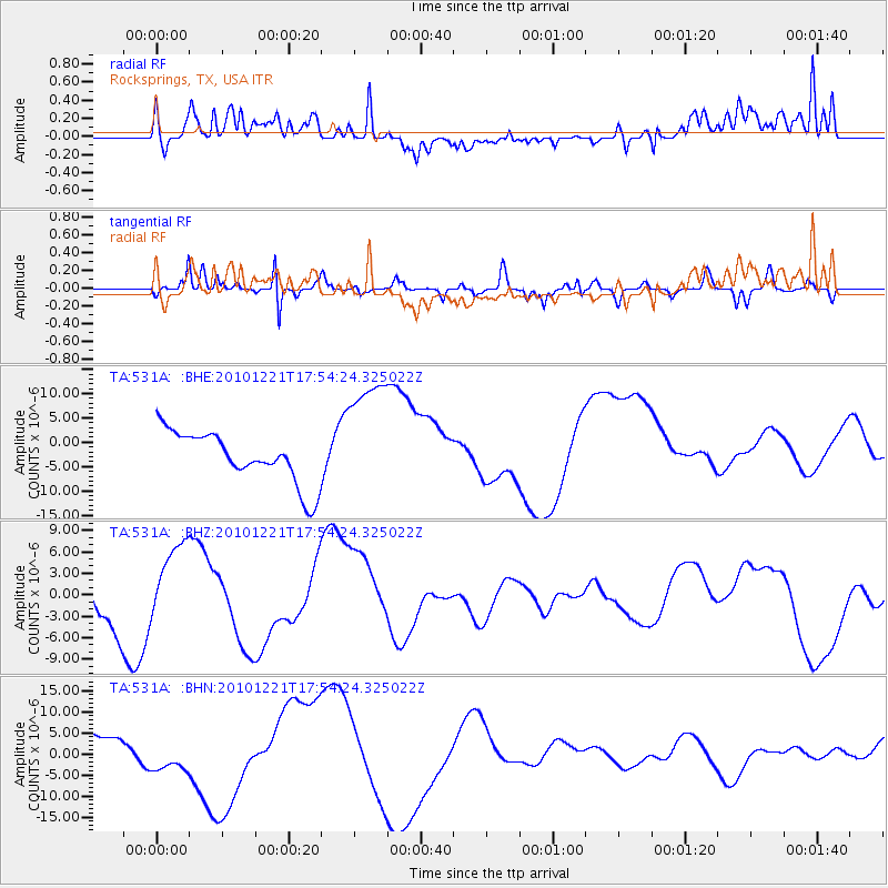
531A Rocksprings, TX, USA - Earthquake Result Viewer
*The percent match for this event was below the threshold and hence no stack was calculated.
| Earthquake location: |
Bonin Islands, Japan Region |
| Earthquake latitude/longitude: |
27.1/143.3 |
| Earthquake time(UTC): |
2010/12/21 (355) 17:41:25 GMT |
| Earthquake Depth: |
7.6 km |
| Earthquake Magnitude: |
5.5 MB |
| Earthquake Catalog/Contributor: |
WHDF/NEIC |
|
| Network: |
TA USArray Transportable Network (new EarthScope stations) |
| Station: |
531A Rocksprings, TX, USA |
| Lat/Lon: |
30.16 N/100.55 W |
| Elevation: |
661 m |
|
| Distance: |
96.5 deg |
| Az: |
51.492 deg |
| Baz: |
306.331 deg |
| Ray Param: |
$rayparam |
*The percent match for this event was below the threshold and hence was not used in the summary stack. |
|
| Radial Match: |
40.369144 % |
| Radial Bump: |
400 |
| Transverse Match: |
75.51937 % |
| Transverse Bump: |
283 |
| SOD ConfigId: |
346175 |
| Insert Time: |
2011-05-24 22:05:04.284 +0000 |
| GWidth: |
2.5 |
| Max Bumps: |
400 |
| Tol: |
0.001 |
|
Signal To Noise
| Channel | StoN | STA | LTA |
| TA:531A: :BHZ:20101221T17:54:24.325022Z | 2.1054156 | 5.461969E-6 | 2.5942477E-6 |
| TA:531A: :BHN:20101221T17:54:24.325022Z | 1.3434021 | 4.6035298E-6 | 3.4267696E-6 |
| TA:531A: :BHE:20101221T17:54:24.325022Z | 2.4833188 | 1.30158305E-5 | 5.2413047E-6 |
| Arrivals |
| Ps | |
| PpPs | |
| PsPs/PpSs | |


