You are here: Home > Network List > TA - USArray Transportable Network (new EarthScope stations) Stations List
> Station 532A Rocksprings, TX, USA > Earthquake Result Viewer
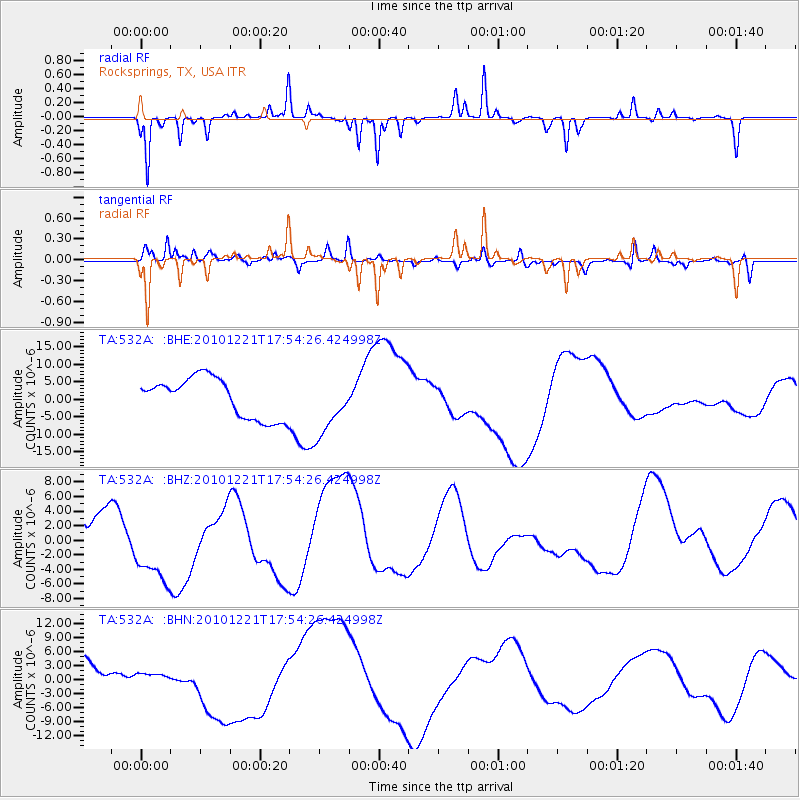
532A Rocksprings, TX, USA - Earthquake Result Viewer
*The percent match for this event was below the threshold and hence no stack was calculated.
| Earthquake location: |
Bonin Islands, Japan Region |
| Earthquake latitude/longitude: |
27.1/143.3 |
| Earthquake time(UTC): |
2010/12/21 (355) 17:41:25 GMT |
| Earthquake Depth: |
7.6 km |
| Earthquake Magnitude: |
5.5 MB |
| Earthquake Catalog/Contributor: |
WHDF/NEIC |
|
| Network: |
TA USArray Transportable Network (new EarthScope stations) |
| Station: |
532A Rocksprings, TX, USA |
| Lat/Lon: |
30.13 N/99.90 W |
| Elevation: |
703 m |
|
| Distance: |
97.0 deg |
| Az: |
51.188 deg |
| Baz: |
306.688 deg |
| Ray Param: |
$rayparam |
*The percent match for this event was below the threshold and hence was not used in the summary stack. |
|
| Radial Match: |
63.08085 % |
| Radial Bump: |
163 |
| Transverse Match: |
55.80407 % |
| Transverse Bump: |
314 |
| SOD ConfigId: |
346175 |
| Insert Time: |
2011-05-24 22:05:42.972 +0000 |
| GWidth: |
2.5 |
| Max Bumps: |
400 |
| Tol: |
0.001 |
|
Signal To Noise
| Channel | StoN | STA | LTA |
| TA:532A: :BHZ:20101221T17:54:26.424998Z | 1.6317942 | 4.9527175E-6 | 3.0351362E-6 |
| TA:532A: :BHN:20101221T17:54:26.424998Z | 0.38069254 | 9.5243524E-7 | 2.501849E-6 |
| TA:532A: :BHE:20101221T17:54:26.424998Z | 1.4395293 | 8.210689E-6 | 5.703732E-6 |
| Arrivals |
| Ps | |
| PpPs | |
| PsPs/PpSs | |


