You are here: Home > Network List > TA - USArray Transportable Network (new EarthScope stations) Stations List
> Station U34A Anderson Ranch, Garber, OK, USA > Earthquake Result Viewer
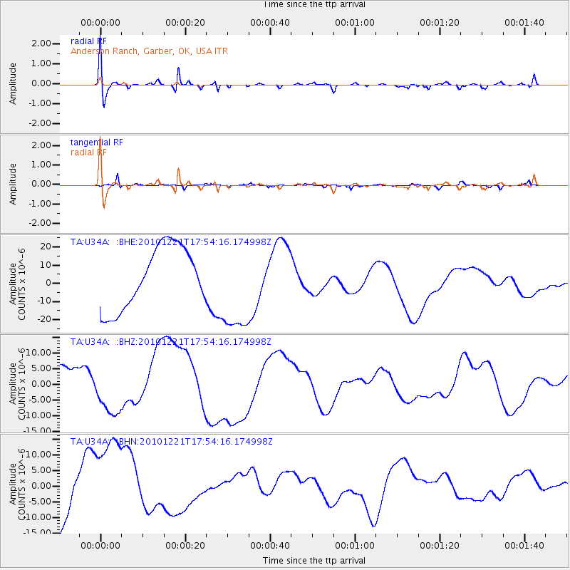
U34A Anderson Ranch, Garber, OK, USA - Earthquake Result Viewer
*The percent match for this event was below the threshold and hence no stack was calculated.
| Earthquake location: |
Bonin Islands, Japan Region |
| Earthquake latitude/longitude: |
27.1/143.3 |
| Earthquake time(UTC): |
2010/12/21 (355) 17:41:25 GMT |
| Earthquake Depth: |
7.6 km |
| Earthquake Magnitude: |
5.5 MB |
| Earthquake Catalog/Contributor: |
WHDF/NEIC |
|
| Network: |
TA USArray Transportable Network (new EarthScope stations) |
| Station: |
U34A Anderson Ranch, Garber, OK, USA |
| Lat/Lon: |
36.44 N/97.54 W |
| Elevation: |
345 m |
|
| Distance: |
94.7 deg |
| Az: |
44.963 deg |
| Baz: |
308.621 deg |
| Ray Param: |
$rayparam |
*The percent match for this event was below the threshold and hence was not used in the summary stack. |
|
| Radial Match: |
32.9134 % |
| Radial Bump: |
400 |
| Transverse Match: |
66.33009 % |
| Transverse Bump: |
213 |
| SOD ConfigId: |
346175 |
| Insert Time: |
2011-05-24 22:13:04.680 +0000 |
| GWidth: |
2.5 |
| Max Bumps: |
400 |
| Tol: |
0.001 |
|
Signal To Noise
| Channel | StoN | STA | LTA |
| TA:U34A: :BHZ:20101221T17:54:16.174998Z | 1.3661735 | 7.646502E-6 | 5.5970213E-6 |
| TA:U34A: :BHN:20101221T17:54:16.174998Z | 1.17712 | 1.5141954E-5 | 1.286356E-5 |
| TA:U34A: :BHE:20101221T17:54:16.174998Z | 1.5346973 | 2.5700198E-5 | 1.6746102E-5 |
| Arrivals |
| Ps | |
| PpPs | |
| PsPs/PpSs | |


