You are here: Home > Network List > TA - USArray Transportable Network (new EarthScope stations) Stations List
> Station W32A Sentinel, OK, USA > Earthquake Result Viewer
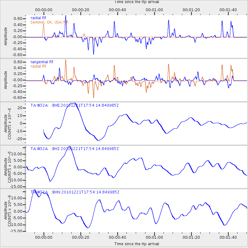
W32A Sentinel, OK, USA - Earthquake Result Viewer
*The percent match for this event was below the threshold and hence no stack was calculated.
| Earthquake location: |
Bonin Islands, Japan Region |
| Earthquake latitude/longitude: |
27.1/143.3 |
| Earthquake time(UTC): |
2010/12/21 (355) 17:41:25 GMT |
| Earthquake Depth: |
7.6 km |
| Earthquake Magnitude: |
5.5 MB |
| Earthquake Catalog/Contributor: |
WHDF/NEIC |
|
| Network: |
TA USArray Transportable Network (new EarthScope stations) |
| Station: |
W32A Sentinel, OK, USA |
| Lat/Lon: |
35.12 N/99.25 W |
| Elevation: |
494 m |
|
| Distance: |
94.4 deg |
| Az: |
46.857 deg |
| Baz: |
307.474 deg |
| Ray Param: |
$rayparam |
*The percent match for this event was below the threshold and hence was not used in the summary stack. |
|
| Radial Match: |
56.58979 % |
| Radial Bump: |
215 |
| Transverse Match: |
63.379257 % |
| Transverse Bump: |
400 |
| SOD ConfigId: |
346175 |
| Insert Time: |
2011-05-24 22:14:57.264 +0000 |
| GWidth: |
2.5 |
| Max Bumps: |
400 |
| Tol: |
0.001 |
|
Signal To Noise
| Channel | StoN | STA | LTA |
| TA:W32A: :BHZ:20101221T17:54:14.849985Z | 1.0349305 | 6.844257E-6 | 6.6132525E-6 |
| TA:W32A: :BHN:20101221T17:54:14.849985Z | 1.4465696 | 1.4305079E-5 | 9.888968E-6 |
| TA:W32A: :BHE:20101221T17:54:14.849985Z | 1.2921029 | 2.0361185E-5 | 1.5758176E-5 |
| Arrivals |
| Ps | |
| PpPs | |
| PsPs/PpSs | |


