You are here: Home > Network List > TA - USArray Transportable Network (new EarthScope stations) Stations List
> Station 534A Blanco, TX, USA > Earthquake Result Viewer
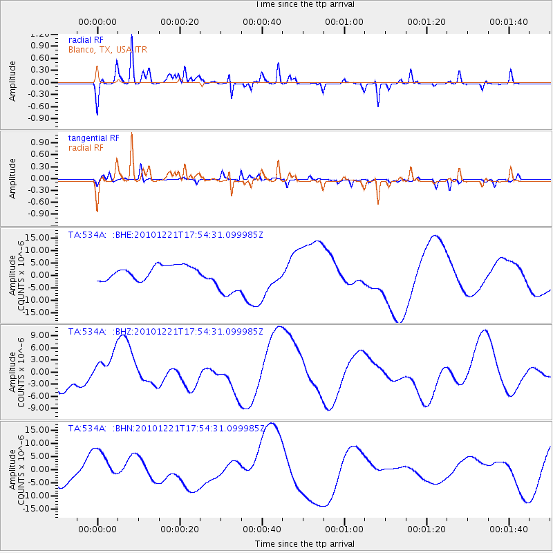
534A Blanco, TX, USA - Earthquake Result Viewer
*The percent match for this event was below the threshold and hence no stack was calculated.
| Earthquake location: |
Bonin Islands, Japan Region |
| Earthquake latitude/longitude: |
27.1/143.3 |
| Earthquake time(UTC): |
2010/12/21 (355) 17:41:25 GMT |
| Earthquake Depth: |
7.6 km |
| Earthquake Magnitude: |
5.5 MB |
| Earthquake Catalog/Contributor: |
WHDF/NEIC |
|
| Network: |
TA USArray Transportable Network (new EarthScope stations) |
| Station: |
534A Blanco, TX, USA |
| Lat/Lon: |
30.03 N/98.48 W |
| Elevation: |
461 m |
|
| Distance: |
98.1 deg |
| Az: |
50.514 deg |
| Baz: |
307.489 deg |
| Ray Param: |
$rayparam |
*The percent match for this event was below the threshold and hence was not used in the summary stack. |
|
| Radial Match: |
76.092155 % |
| Radial Bump: |
261 |
| Transverse Match: |
58.88659 % |
| Transverse Bump: |
275 |
| SOD ConfigId: |
346175 |
| Insert Time: |
2011-05-24 22:16:00.416 +0000 |
| GWidth: |
2.5 |
| Max Bumps: |
400 |
| Tol: |
0.001 |
|
Signal To Noise
| Channel | StoN | STA | LTA |
| TA:534A: :BHZ:20101221T17:54:31.099985Z | 1.3135424 | 4.1372514E-6 | 3.14969E-6 |
| TA:534A: :BHN:20101221T17:54:31.099985Z | 1.6629066 | 6.0228504E-6 | 3.6218812E-6 |
| TA:534A: :BHE:20101221T17:54:31.099985Z | 3.2663367 | 8.46515E-6 | 2.5916343E-6 |
| Arrivals |
| Ps | |
| PpPs | |
| PsPs/PpSs | |


