You are here: Home > Network List > TA - USArray Transportable Network (new EarthScope stations) Stations List
> Station 633A Saathoff Ranch, Hondo, TX, USA > Earthquake Result Viewer
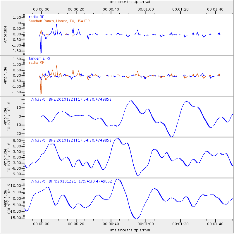
633A Saathoff Ranch, Hondo, TX, USA - Earthquake Result Viewer
*The percent match for this event was below the threshold and hence no stack was calculated.
| Earthquake location: |
Bonin Islands, Japan Region |
| Earthquake latitude/longitude: |
27.1/143.3 |
| Earthquake time(UTC): |
2010/12/21 (355) 17:41:25 GMT |
| Earthquake Depth: |
7.6 km |
| Earthquake Magnitude: |
5.5 MB |
| Earthquake Catalog/Contributor: |
WHDF/NEIC |
|
| Network: |
TA USArray Transportable Network (new EarthScope stations) |
| Station: |
633A Saathoff Ranch, Hondo, TX, USA |
| Lat/Lon: |
29.46 N/99.18 W |
| Elevation: |
320 m |
|
| Distance: |
97.9 deg |
| Az: |
51.343 deg |
| Baz: |
307.027 deg |
| Ray Param: |
$rayparam |
*The percent match for this event was below the threshold and hence was not used in the summary stack. |
|
| Radial Match: |
70.80814 % |
| Radial Bump: |
153 |
| Transverse Match: |
39.283863 % |
| Transverse Bump: |
233 |
| SOD ConfigId: |
346175 |
| Insert Time: |
2011-05-24 22:20:51.266 +0000 |
| GWidth: |
2.5 |
| Max Bumps: |
400 |
| Tol: |
0.001 |
|
Signal To Noise
| Channel | StoN | STA | LTA |
| TA:633A: :BHZ:20101221T17:54:30.474985Z | 1.7235662 | 4.6855134E-6 | 2.7184992E-6 |
| TA:633A: :BHN:20101221T17:54:30.474985Z | 2.8325753 | 9.1429365E-6 | 3.2277821E-6 |
| TA:633A: :BHE:20101221T17:54:30.474985Z | 0.9976902 | 3.2056535E-6 | 3.2130752E-6 |
| Arrivals |
| Ps | |
| PpPs | |
| PsPs/PpSs | |


