You are here: Home > Network List > TA - USArray Transportable Network (new EarthScope stations) Stations List
> Station 435B Jarrell, TX, USA > Earthquake Result Viewer
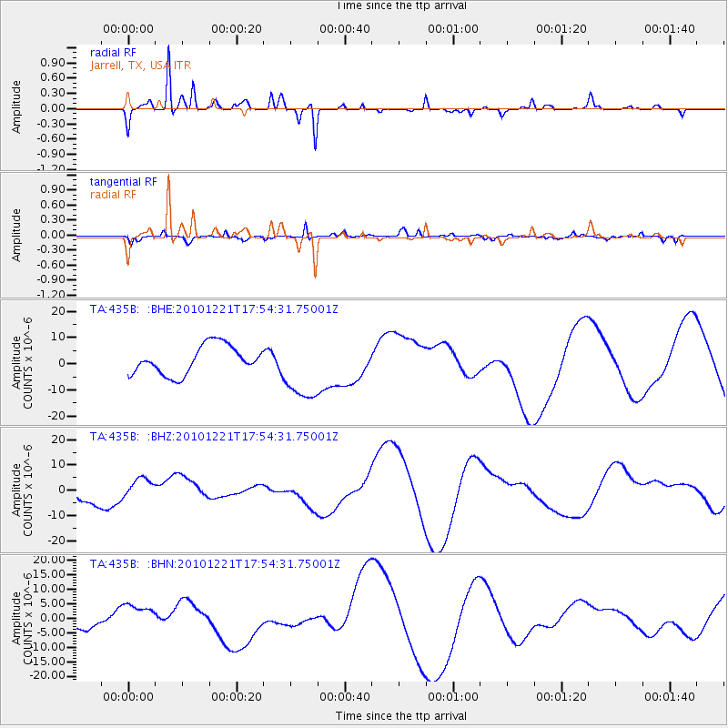
435B Jarrell, TX, USA - Earthquake Result Viewer
*The percent match for this event was below the threshold and hence no stack was calculated.
| Earthquake location: |
Bonin Islands, Japan Region |
| Earthquake latitude/longitude: |
27.1/143.3 |
| Earthquake time(UTC): |
2010/12/21 (355) 17:41:25 GMT |
| Earthquake Depth: |
7.6 km |
| Earthquake Magnitude: |
5.5 MB |
| Earthquake Catalog/Contributor: |
WHDF/NEIC |
|
| Network: |
TA USArray Transportable Network (new EarthScope stations) |
| Station: |
435B Jarrell, TX, USA |
| Lat/Lon: |
30.78 N/97.58 W |
| Elevation: |
248 m |
|
| Distance: |
98.2 deg |
| Az: |
49.438 deg |
| Baz: |
308.089 deg |
| Ray Param: |
$rayparam |
*The percent match for this event was below the threshold and hence was not used in the summary stack. |
|
| Radial Match: |
74.78612 % |
| Radial Bump: |
251 |
| Transverse Match: |
59.67912 % |
| Transverse Bump: |
283 |
| SOD ConfigId: |
346175 |
| Insert Time: |
2011-05-24 22:22:01.853 +0000 |
| GWidth: |
2.5 |
| Max Bumps: |
400 |
| Tol: |
0.001 |
|
Signal To Noise
| Channel | StoN | STA | LTA |
| TA:435B: :BHZ:20101221T17:54:31.75001Z | 1.1351335 | 3.9932647E-6 | 3.5178812E-6 |
| TA:435B: :BHN:20101221T17:54:31.75001Z | 1.0661753 | 4.4428216E-6 | 4.1670646E-6 |
| TA:435B: :BHE:20101221T17:54:31.75001Z | 2.3326907 | 1.2630476E-5 | 5.4145526E-6 |
| Arrivals |
| Ps | |
| PpPs | |
| PsPs/PpSs | |


