You are here: Home > Network List > TA - USArray Transportable Network (new EarthScope stations) Stations List
> Station X37A Clayton, OK, USA > Earthquake Result Viewer
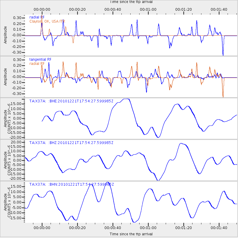
X37A Clayton, OK, USA - Earthquake Result Viewer
*The percent match for this event was below the threshold and hence no stack was calculated.
| Earthquake location: |
Bonin Islands, Japan Region |
| Earthquake latitude/longitude: |
27.1/143.3 |
| Earthquake time(UTC): |
2010/12/21 (355) 17:41:25 GMT |
| Earthquake Depth: |
7.6 km |
| Earthquake Magnitude: |
5.5 MB |
| Earthquake Catalog/Contributor: |
WHDF/NEIC |
|
| Network: |
TA USArray Transportable Network (new EarthScope stations) |
| Station: |
X37A Clayton, OK, USA |
| Lat/Lon: |
34.59 N/95.37 W |
| Elevation: |
207 m |
|
| Distance: |
97.3 deg |
| Az: |
45.275 deg |
| Baz: |
309.84 deg |
| Ray Param: |
$rayparam |
*The percent match for this event was below the threshold and hence was not used in the summary stack. |
|
| Radial Match: |
20.208475 % |
| Radial Bump: |
194 |
| Transverse Match: |
51.86422 % |
| Transverse Bump: |
400 |
| SOD ConfigId: |
346175 |
| Insert Time: |
2011-05-24 22:25:46.645 +0000 |
| GWidth: |
2.5 |
| Max Bumps: |
400 |
| Tol: |
0.001 |
|
Signal To Noise
| Channel | StoN | STA | LTA |
| TA:X37A: :BHZ:20101221T17:54:27.599985Z | 2.8115625 | 9.794228E-6 | 3.4835532E-6 |
| TA:X37A: :BHN:20101221T17:54:27.599985Z | 3.5589924 | 9.530829E-6 | 2.677957E-6 |
| TA:X37A: :BHE:20101221T17:54:27.599985Z | 3.6563592 | 1.6290123E-5 | 4.4552853E-6 |
| Arrivals |
| Ps | |
| PpPs | |
| PsPs/PpSs | |


