You are here: Home > Network List > TA - USArray Transportable Network (new EarthScope stations) Stations List
> Station P35A Duane Minner, Soldier, KS, USA > Earthquake Result Viewer
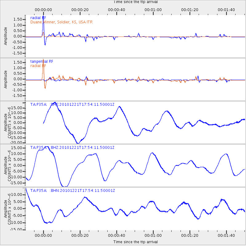
P35A Duane Minner, Soldier, KS, USA - Earthquake Result Viewer
*The percent match for this event was below the threshold and hence no stack was calculated.
| Earthquake location: |
Bonin Islands, Japan Region |
| Earthquake latitude/longitude: |
27.1/143.3 |
| Earthquake time(UTC): |
2010/12/21 (355) 17:41:25 GMT |
| Earthquake Depth: |
7.6 km |
| Earthquake Magnitude: |
5.5 MB |
| Earthquake Catalog/Contributor: |
WHDF/NEIC |
|
| Network: |
TA USArray Transportable Network (new EarthScope stations) |
| Station: |
P35A Duane Minner, Soldier, KS, USA |
| Lat/Lon: |
39.53 N/96.02 W |
| Elevation: |
418 m |
|
| Distance: |
93.7 deg |
| Az: |
41.805 deg |
| Baz: |
309.784 deg |
| Ray Param: |
$rayparam |
*The percent match for this event was below the threshold and hence was not used in the summary stack. |
|
| Radial Match: |
42.42525 % |
| Radial Bump: |
400 |
| Transverse Match: |
67.57745 % |
| Transverse Bump: |
400 |
| SOD ConfigId: |
346175 |
| Insert Time: |
2011-05-24 22:28:51.016 +0000 |
| GWidth: |
2.5 |
| Max Bumps: |
400 |
| Tol: |
0.001 |
|
Signal To Noise
| Channel | StoN | STA | LTA |
| TA:P35A: :BHZ:20101221T17:54:11.50001Z | 3.6451938 | 1.7949644E-5 | 4.924195E-6 |
| TA:P35A: :BHN:20101221T17:54:11.50001Z | 0.8067572 | 9.96136E-6 | 1.2347407E-5 |
| TA:P35A: :BHE:20101221T17:54:11.50001Z | 0.26849967 | 3.6436875E-6 | 1.3570547E-5 |
| Arrivals |
| Ps | |
| PpPs | |
| PsPs/PpSs | |


