You are here: Home > Network List > TA - USArray Transportable Network (new EarthScope stations) Stations List
> Station V38A Canehill, AR, USA > Earthquake Result Viewer
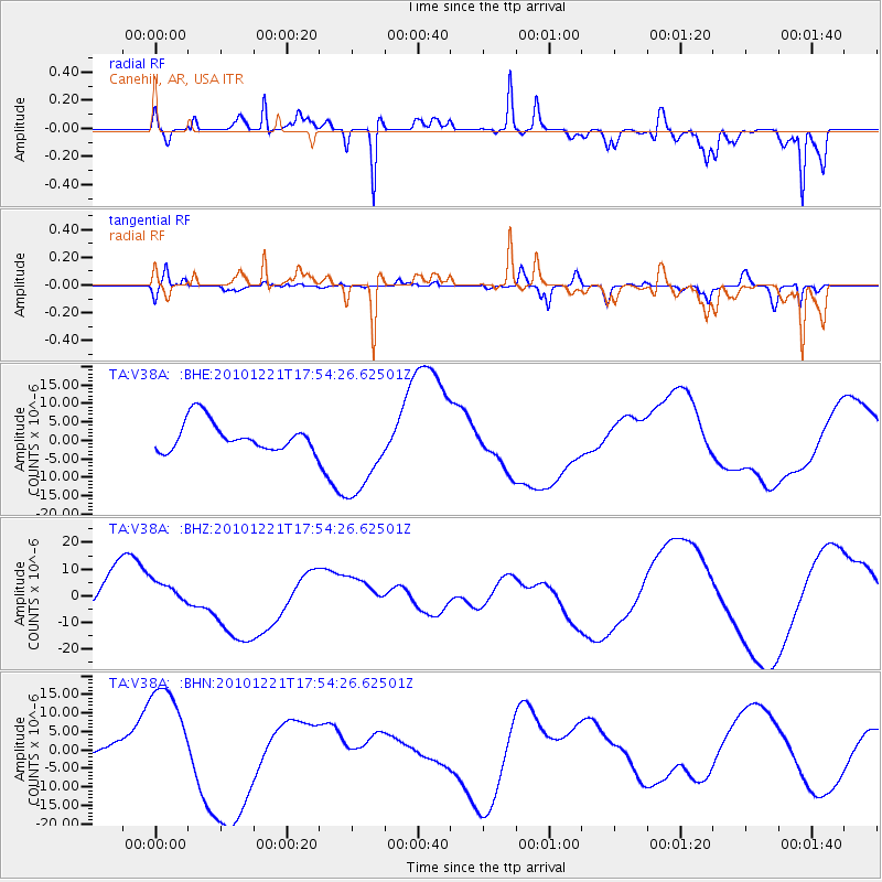
V38A Canehill, AR, USA - Earthquake Result Viewer
*The percent match for this event was below the threshold and hence no stack was calculated.
| Earthquake location: |
Bonin Islands, Japan Region |
| Earthquake latitude/longitude: |
27.1/143.3 |
| Earthquake time(UTC): |
2010/12/21 (355) 17:41:25 GMT |
| Earthquake Depth: |
7.6 km |
| Earthquake Magnitude: |
5.5 MB |
| Earthquake Catalog/Contributor: |
WHDF/NEIC |
|
| Network: |
TA USArray Transportable Network (new EarthScope stations) |
| Station: |
V38A Canehill, AR, USA |
| Lat/Lon: |
35.86 N/94.41 W |
| Elevation: |
372 m |
|
| Distance: |
97.0 deg |
| Az: |
43.784 deg |
| Baz: |
310.58 deg |
| Ray Param: |
$rayparam |
*The percent match for this event was below the threshold and hence was not used in the summary stack. |
|
| Radial Match: |
66.55779 % |
| Radial Bump: |
400 |
| Transverse Match: |
51.76868 % |
| Transverse Bump: |
400 |
| SOD ConfigId: |
346175 |
| Insert Time: |
2011-05-24 22:32:49.252 +0000 |
| GWidth: |
2.5 |
| Max Bumps: |
400 |
| Tol: |
0.001 |
|
Signal To Noise
| Channel | StoN | STA | LTA |
| TA:V38A: :BHZ:20101221T17:54:26.62501Z | 1.0775349 | 5.4104908E-6 | 5.0211747E-6 |
| TA:V38A: :BHN:20101221T17:54:26.62501Z | 4.173556 | 1.5015488E-5 | 3.5977687E-6 |
| TA:V38A: :BHE:20101221T17:54:26.62501Z | 3.1524444 | 1.2488719E-5 | 3.9615984E-6 |
| Arrivals |
| Ps | |
| PpPs | |
| PsPs/PpSs | |


