You are here: Home > Network List > TA - USArray Transportable Network (new EarthScope stations) Stations List
> Station A04D Lummi Island, WA, USA > Earthquake Result Viewer
A04D Lummi Island, WA, USA - Earthquake Result Viewer

| Earthquake location: |
Bonin Islands, Japan Region |
| Earthquake latitude/longitude: |
27.1/143.3 |
| Earthquake time(UTC): |
2010/12/21 (355) 17:41:25 GMT |
| Earthquake Depth: |
7.6 km |
| Earthquake Magnitude: |
5.5 MB |
| Earthquake Catalog/Contributor: |
WHDF/NEIC |
|
| Network: |
TA USArray Transportable Network (new EarthScope stations) |
| Station: |
A04D Lummi Island, WA, USA |
| Lat/Lon: |
48.72 N/122.71 W |
| Elevation: |
13 m |
|
| Distance: |
72.6 deg |
| Az: |
43.8 deg |
| Baz: |
291.274 deg |
| Ray Param: |
0.053527776 |
| Estimated Moho Depth: |
30.5 km |
| Estimated Crust Vp/Vs: |
1.76 |
| Assumed Crust Vp: |
6.566 km/s |
| Estimated Crust Vs: |
3.736 km/s |
| Estimated Crust Poisson's Ratio: |
0.26 |
|
| Radial Match: |
86.42849 % |
| Radial Bump: |
400 |
| Transverse Match: |
55.922707 % |
| Transverse Bump: |
249 |
| SOD ConfigId: |
346175 |
| Insert Time: |
2011-05-24 22:35:14.499 +0000 |
| GWidth: |
2.5 |
| Max Bumps: |
400 |
| Tol: |
0.001 |
|
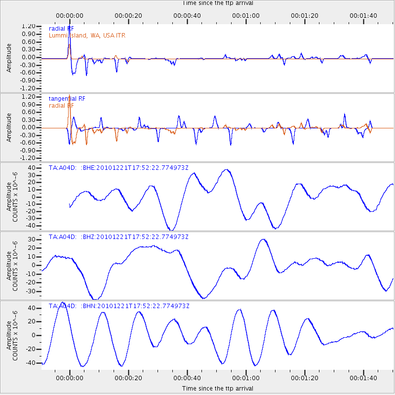
Signal To Noise
| Channel | StoN | STA | LTA |
| TA:A04D: :BHZ:20101221T17:52:22.774973Z | 0.81741625 | 7.435758E-6 | 9.0966605E-6 |
| TA:A04D: :BHN:20101221T17:52:22.774973Z | 1.217982 | 2.9036652E-5 | 2.3839966E-5 |
| TA:A04D: :BHE:20101221T17:52:22.774973Z | 3.4221413 | 2.8412655E-5 | 8.302596E-6 |
| Arrivals |
| Ps | 3.7 SECOND |
| PpPs | 12 SECOND |
| PsPs/PpSs | 16 SECOND |


