You are here: Home > Network List > TA - USArray Transportable Network (new EarthScope stations) Stations List
> Station C39A Grand Marais, MN, USA > Earthquake Result Viewer
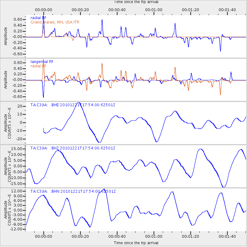
C39A Grand Marais, MN, USA - Earthquake Result Viewer
*The percent match for this event was below the threshold and hence no stack was calculated.
| Earthquake location: |
Bonin Islands, Japan Region |
| Earthquake latitude/longitude: |
27.1/143.3 |
| Earthquake time(UTC): |
2010/12/21 (355) 17:41:25 GMT |
| Earthquake Depth: |
7.6 km |
| Earthquake Magnitude: |
5.5 MB |
| Earthquake Catalog/Contributor: |
WHDF/NEIC |
|
| Network: |
TA USArray Transportable Network (new EarthScope stations) |
| Station: |
C39A Grand Marais, MN, USA |
| Lat/Lon: |
47.82 N/90.13 W |
| Elevation: |
341 m |
|
| Distance: |
91.3 deg |
| Az: |
32.785 deg |
| Baz: |
314.248 deg |
| Ray Param: |
$rayparam |
*The percent match for this event was below the threshold and hence was not used in the summary stack. |
|
| Radial Match: |
41.788357 % |
| Radial Bump: |
273 |
| Transverse Match: |
57.52352 % |
| Transverse Bump: |
306 |
| SOD ConfigId: |
346175 |
| Insert Time: |
2011-05-24 22:37:06.253 +0000 |
| GWidth: |
2.5 |
| Max Bumps: |
400 |
| Tol: |
0.001 |
|
Signal To Noise
| Channel | StoN | STA | LTA |
| TA:C39A: :BHZ:20101221T17:54:00.62501Z | 1.4425578 | 7.3515334E-6 | 5.096179E-6 |
| TA:C39A: :BHN:20101221T17:54:00.62501Z | 0.8047934 | 8.112292E-6 | 1.0079968E-5 |
| TA:C39A: :BHE:20101221T17:54:00.62501Z | 1.6933799 | 2.0291967E-5 | 1.1983116E-5 |
| Arrivals |
| Ps | |
| PpPs | |
| PsPs/PpSs | |


