You are here: Home > Network List > TA - USArray Transportable Network (new EarthScope stations) Stations List
> Station M37A Trindle Farm, Earlham, IA, USA > Earthquake Result Viewer
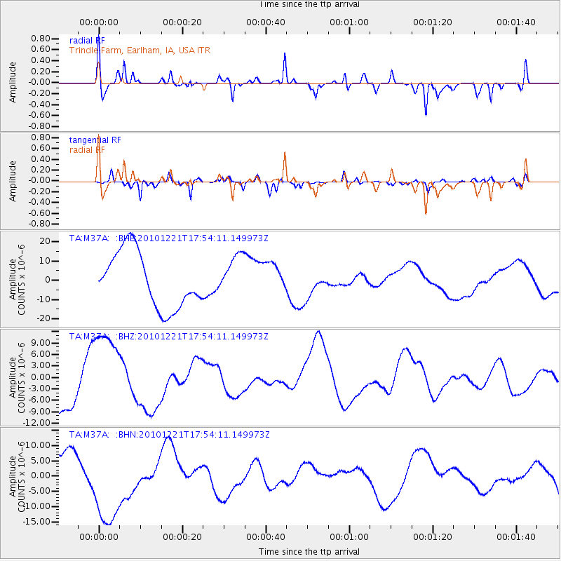
M37A Trindle Farm, Earlham, IA, USA - Earthquake Result Viewer
*The percent match for this event was below the threshold and hence no stack was calculated.
| Earthquake location: |
Bonin Islands, Japan Region |
| Earthquake latitude/longitude: |
27.1/143.3 |
| Earthquake time(UTC): |
2010/12/21 (355) 17:41:25 GMT |
| Earthquake Depth: |
7.6 km |
| Earthquake Magnitude: |
5.5 MB |
| Earthquake Catalog/Contributor: |
WHDF/NEIC |
|
| Network: |
TA USArray Transportable Network (new EarthScope stations) |
| Station: |
M37A Trindle Farm, Earlham, IA, USA |
| Lat/Lon: |
41.40 N/94.06 W |
| Elevation: |
325 m |
|
| Distance: |
93.6 deg |
| Az: |
39.404 deg |
| Baz: |
311.206 deg |
| Ray Param: |
$rayparam |
*The percent match for this event was below the threshold and hence was not used in the summary stack. |
|
| Radial Match: |
23.545033 % |
| Radial Bump: |
277 |
| Transverse Match: |
51.535656 % |
| Transverse Bump: |
295 |
| SOD ConfigId: |
346175 |
| Insert Time: |
2011-05-24 22:38:20.891 +0000 |
| GWidth: |
2.5 |
| Max Bumps: |
400 |
| Tol: |
0.001 |
|
Signal To Noise
| Channel | StoN | STA | LTA |
| TA:M37A: :BHZ:20101221T17:54:11.149973Z | 2.2059195 | 1.2039563E-5 | 5.4578436E-6 |
| TA:M37A: :BHN:20101221T17:54:11.149973Z | 1.2901629 | 1.4055344E-5 | 1.08942395E-5 |
| TA:M37A: :BHE:20101221T17:54:11.149973Z | 0.7653321 | 1.10262645E-5 | 1.4407162E-5 |
| Arrivals |
| Ps | |
| PpPs | |
| PsPs/PpSs | |


