You are here: Home > Network List > TA - USArray Transportable Network (new EarthScope stations) Stations List
> Station L38A Oak Wood Farm, Albion, IA, USA > Earthquake Result Viewer
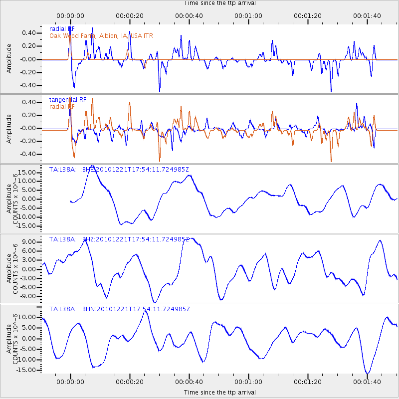
L38A Oak Wood Farm, Albion, IA, USA - Earthquake Result Viewer
*The percent match for this event was below the threshold and hence no stack was calculated.
| Earthquake location: |
Bonin Islands, Japan Region |
| Earthquake latitude/longitude: |
27.1/143.3 |
| Earthquake time(UTC): |
2010/12/21 (355) 17:41:25 GMT |
| Earthquake Depth: |
7.6 km |
| Earthquake Magnitude: |
5.5 MB |
| Earthquake Catalog/Contributor: |
WHDF/NEIC |
|
| Network: |
TA USArray Transportable Network (new EarthScope stations) |
| Station: |
L38A Oak Wood Farm, Albion, IA, USA |
| Lat/Lon: |
42.14 N/92.96 W |
| Elevation: |
300 m |
|
| Distance: |
93.8 deg |
| Az: |
38.305 deg |
| Baz: |
312.005 deg |
| Ray Param: |
$rayparam |
*The percent match for this event was below the threshold and hence was not used in the summary stack. |
|
| Radial Match: |
36.70479 % |
| Radial Bump: |
328 |
| Transverse Match: |
51.77905 % |
| Transverse Bump: |
400 |
| SOD ConfigId: |
346175 |
| Insert Time: |
2011-05-24 22:39:00.826 +0000 |
| GWidth: |
2.5 |
| Max Bumps: |
400 |
| Tol: |
0.001 |
|
Signal To Noise
| Channel | StoN | STA | LTA |
| TA:L38A: :BHZ:20101221T17:54:11.724985Z | 3.4003658 | 8.18919E-6 | 2.408326E-6 |
| TA:L38A: :BHN:20101221T17:54:11.724985Z | 0.47026798 | 4.572292E-6 | 9.722737E-6 |
| TA:L38A: :BHE:20101221T17:54:11.724985Z | 0.53774756 | 5.517166E-6 | 1.025977E-5 |
| Arrivals |
| Ps | |
| PpPs | |
| PsPs/PpSs | |


