You are here: Home > Network List > US - United States National Seismic Network Stations List
> Station TPNV Topopah Spring, Nevada, USA > Earthquake Result Viewer
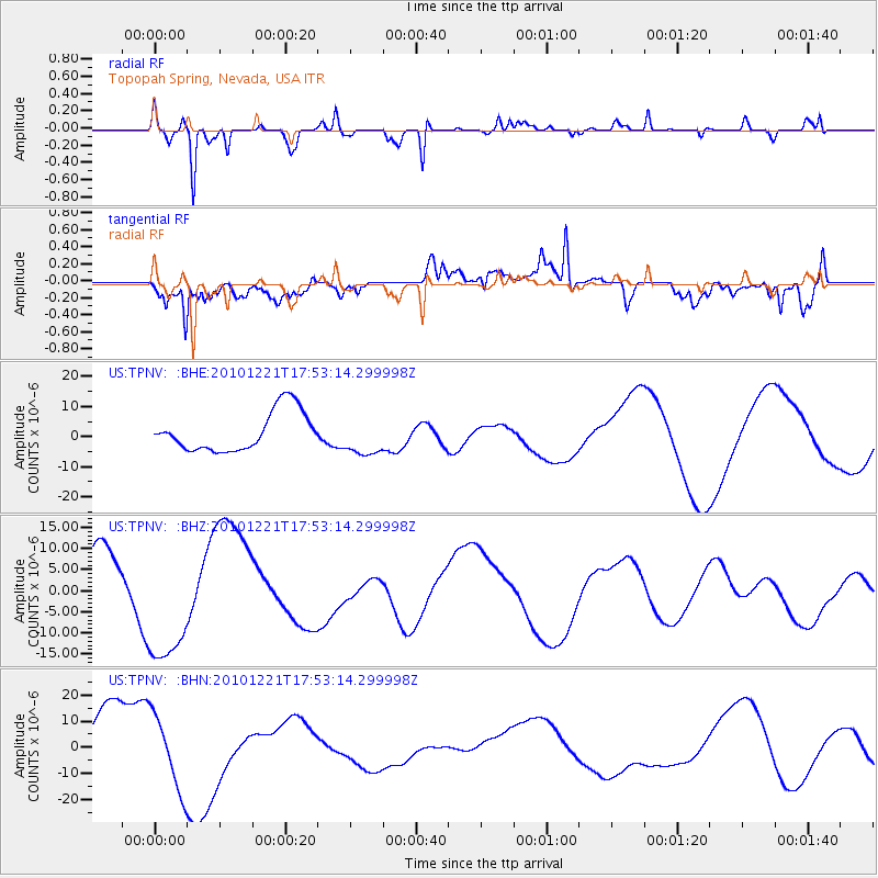
TPNV Topopah Spring, Nevada, USA - Earthquake Result Viewer
*The percent match for this event was below the threshold and hence no stack was calculated.
| Earthquake location: |
Bonin Islands, Japan Region |
| Earthquake latitude/longitude: |
27.1/143.3 |
| Earthquake time(UTC): |
2010/12/21 (355) 17:41:25 GMT |
| Earthquake Depth: |
7.6 km |
| Earthquake Magnitude: |
5.5 MB |
| Earthquake Catalog/Contributor: |
WHDF/NEIC |
|
| Network: |
US United States National Seismic Network |
| Station: |
TPNV Topopah Spring, Nevada, USA |
| Lat/Lon: |
36.95 N/116.25 W |
| Elevation: |
1600 m |
|
| Distance: |
81.9 deg |
| Az: |
52.736 deg |
| Baz: |
297.656 deg |
| Ray Param: |
$rayparam |
*The percent match for this event was below the threshold and hence was not used in the summary stack. |
|
| Radial Match: |
89.671 % |
| Radial Bump: |
231 |
| Transverse Match: |
54.897457 % |
| Transverse Bump: |
400 |
| SOD ConfigId: |
346175 |
| Insert Time: |
2011-05-24 22:42:10.690 +0000 |
| GWidth: |
2.5 |
| Max Bumps: |
400 |
| Tol: |
0.001 |
|
Signal To Noise
| Channel | StoN | STA | LTA |
| US:TPNV: :BHZ:20101221T17:53:14.299998Z | 2.0502048 | 1.5643845E-5 | 7.630382E-6 |
| US:TPNV: :BHN:20101221T17:53:14.299998Z | 1.6475915 | 1.4131111E-5 | 8.57683E-6 |
| US:TPNV: :BHE:20101221T17:53:14.299998Z | 0.9590255 | 6.3129146E-6 | 6.582635E-6 |
| Arrivals |
| Ps | |
| PpPs | |
| PsPs/PpSs | |


