You are here: Home > Network List > UW - Pacific Northwest Regional Seismic Network Stations List
> Station LEBA Lebam, WA, USA > Earthquake Result Viewer
LEBA Lebam, WA, USA - Earthquake Result Viewer
| Earthquake location: |
Bonin Islands, Japan Region |
| Earthquake latitude/longitude: |
27.1/143.3 |
| Earthquake time(UTC): |
2010/12/21 (355) 17:41:25 GMT |
| Earthquake Depth: |
7.6 km |
| Earthquake Magnitude: |
5.5 MB |
| Earthquake Catalog/Contributor: |
WHDF/NEIC |
|
| Network: |
UW Pacific Northwest Regional Seismic Network |
| Station: |
LEBA Lebam, WA, USA |
| Lat/Lon: |
46.55 N/123.56 W |
| Elevation: |
73 m |
|
| Distance: |
72.9 deg |
| Az: |
46.142 deg |
| Baz: |
291.337 deg |
| Ray Param: |
0.05336363 |
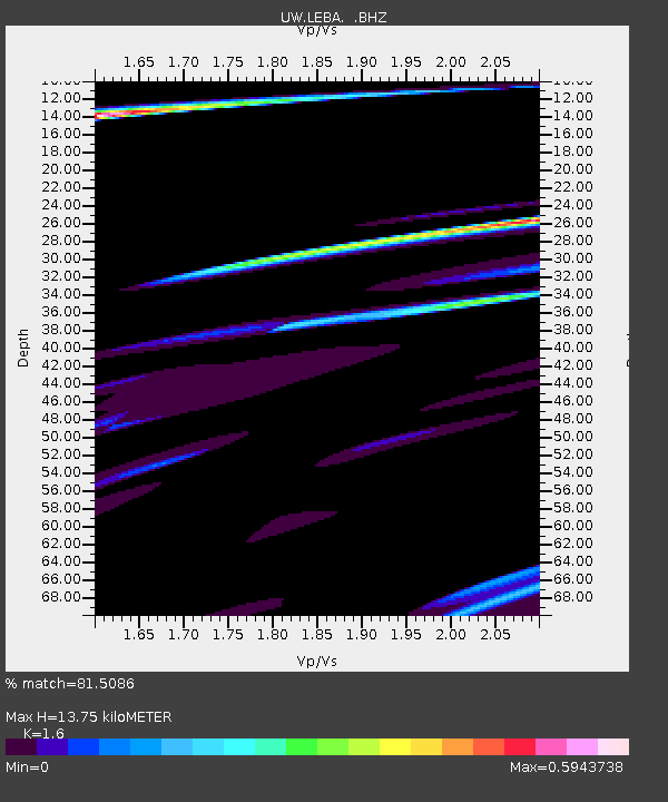
| Estimated Moho Depth: |
13.75 km |
| Estimated Crust Vp/Vs: |
1.60 |
| Assumed Crust Vp: |
6.566 km/s |
| Estimated Crust Vs: |
4.104 km/s |
| Estimated Crust Poisson's Ratio: |
0.18 |
|
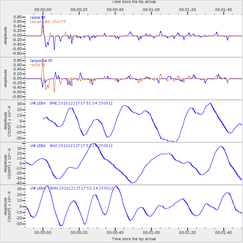
| Radial Match: |
81.5086 % |
| Radial Bump: |
400 |
| Transverse Match: |
67.048164 % |
| Transverse Bump: |
190 |
| SOD ConfigId: |
346175 |
| Insert Time: |
2011-05-24 22:47:45.585 +0000 |
| GWidth: |
2.5 |
| Max Bumps: |
400 |
| Tol: |
0.001 |
|
Signal To Noise
| Channel | StoN | STA | LTA |
| UW:LEBA: :BHZ:20101221T17:52:24.25001Z | 0.94393885 | 8.224741E-6 | 8.713213E-6 |
| UW:LEBA: :BHN:20101221T17:52:24.25001Z | 2.9267442 | 2.9549226E-5 | 1.0096279E-5 |
| UW:LEBA: :BHE:20101221T17:52:24.25001Z | 0.7305607 | 9.6858685E-6 | 1.3258129E-5 |
| Arrivals |
| Ps | 1.3 SECOND |
| PpPs | 5.2 SECOND |
| PsPs/PpSs | 6.5 SECOND |


