You are here: Home > Network List > IU - Global Seismograph Network (GSN - IRIS/USGS) Stations List
> Station SLBS Sierra la Laguna Baja California Sur, Mexico > Earthquake Result Viewer
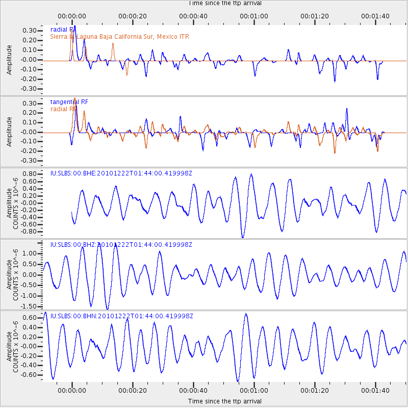
SLBS Sierra la Laguna Baja California Sur, Mexico - Earthquake Result Viewer
*The percent match for this event was below the threshold and hence no stack was calculated.
| Earthquake location: |
Bonin Islands, Japan Region |
| Earthquake latitude/longitude: |
26.7/143.5 |
| Earthquake time(UTC): |
2010/12/22 (356) 01:31:17 GMT |
| Earthquake Depth: |
10 km |
| Earthquake Magnitude: |
5.5 MB, 5.2 MS, 5.6 MW |
| Earthquake Catalog/Contributor: |
WHDF/NEIC |
|
| Network: |
IU Global Seismograph Network (GSN - IRIS/USGS) |
| Station: |
SLBS Sierra la Laguna Baja California Sur, Mexico |
| Lat/Lon: |
23.69 N/109.94 W |
| Elevation: |
825 m |
|
| Distance: |
93.1 deg |
| Az: |
61.67 deg |
| Baz: |
300.776 deg |
| Ray Param: |
$rayparam |
*The percent match for this event was below the threshold and hence was not used in the summary stack. |
|
| Radial Match: |
55.430805 % |
| Radial Bump: |
400 |
| Transverse Match: |
63.774372 % |
| Transverse Bump: |
331 |
| SOD ConfigId: |
346175 |
| Insert Time: |
2011-05-24 23:15:22.632 +0000 |
| GWidth: |
2.5 |
| Max Bumps: |
400 |
| Tol: |
0.001 |
|
Signal To Noise
| Channel | StoN | STA | LTA |
| IU:SLBS:00:BHZ:20101222T01:44:00.419998Z | 1.6892569 | 8.421047E-7 | 4.9850604E-7 |
| IU:SLBS:00:BHN:20101222T01:44:00.419998Z | 0.6398374 | 2.661387E-7 | 4.159474E-7 |
| IU:SLBS:00:BHE:20101222T01:44:00.419998Z | 0.9817058 | 2.460465E-7 | 2.5063162E-7 |
| Arrivals |
| Ps | |
| PpPs | |
| PsPs/PpSs | |


