You are here: Home > Network List > TA - USArray Transportable Network (new EarthScope stations) Stations List
> Station H27A Howes, SD, USA > Earthquake Result Viewer
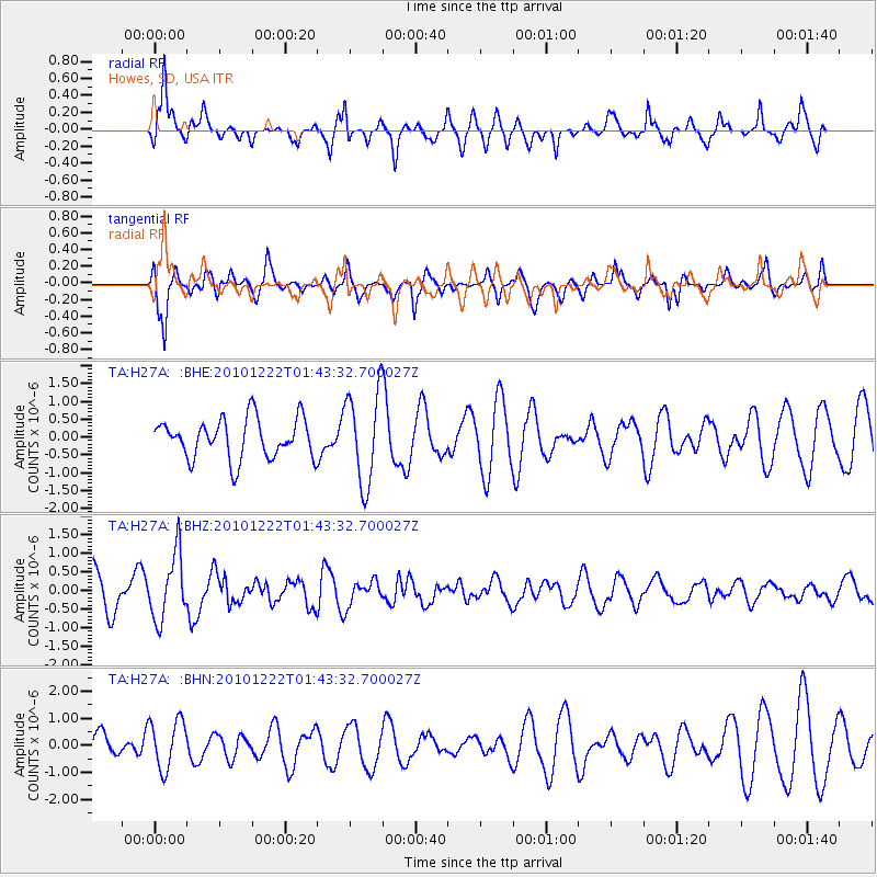
H27A Howes, SD, USA - Earthquake Result Viewer
*The percent match for this event was below the threshold and hence no stack was calculated.
| Earthquake location: |
Bonin Islands, Japan Region |
| Earthquake latitude/longitude: |
26.7/143.5 |
| Earthquake time(UTC): |
2010/12/22 (356) 01:31:17 GMT |
| Earthquake Depth: |
10 km |
| Earthquake Magnitude: |
5.5 MB, 5.2 MS, 5.6 MW |
| Earthquake Catalog/Contributor: |
WHDF/NEIC |
|
| Network: |
TA USArray Transportable Network (new EarthScope stations) |
| Station: |
H27A Howes, SD, USA |
| Lat/Lon: |
44.63 N/102.08 W |
| Elevation: |
748 m |
|
| Distance: |
87.2 deg |
| Az: |
40.621 deg |
| Baz: |
305.319 deg |
| Ray Param: |
$rayparam |
*The percent match for this event was below the threshold and hence was not used in the summary stack. |
|
| Radial Match: |
73.7119 % |
| Radial Bump: |
330 |
| Transverse Match: |
74.39647 % |
| Transverse Bump: |
356 |
| SOD ConfigId: |
346175 |
| Insert Time: |
2011-05-24 23:28:50.183 +0000 |
| GWidth: |
2.5 |
| Max Bumps: |
400 |
| Tol: |
0.001 |
|
Signal To Noise
| Channel | StoN | STA | LTA |
| TA:H27A: :BHZ:20101222T01:43:32.700027Z | 1.5921339 | 8.875047E-7 | 5.5743095E-7 |
| TA:H27A: :BHN:20101222T01:43:32.700027Z | 1.8754356 | 9.194512E-7 | 4.902601E-7 |
| TA:H27A: :BHE:20101222T01:43:32.700027Z | 2.3240178 | 1.2918048E-6 | 5.558498E-7 |
| Arrivals |
| Ps | |
| PpPs | |
| PsPs/PpSs | |


