You are here: Home > Network List > TA - USArray Transportable Network (new EarthScope stations) Stations List
> Station F30A Leola, SD, USA > Earthquake Result Viewer
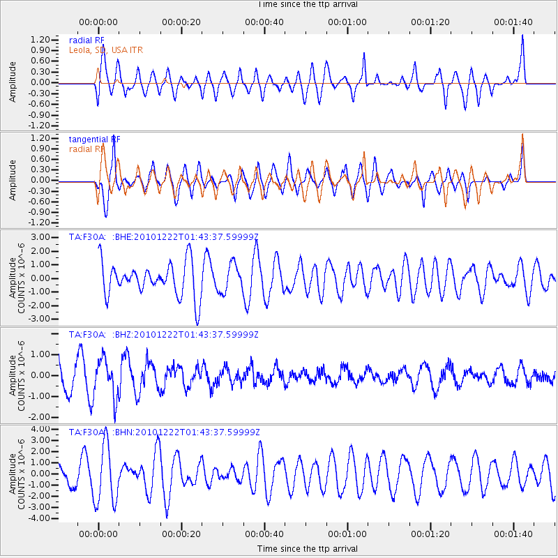
F30A Leola, SD, USA - Earthquake Result Viewer
*The percent match for this event was below the threshold and hence no stack was calculated.
| Earthquake location: |
Bonin Islands, Japan Region |
| Earthquake latitude/longitude: |
26.7/143.5 |
| Earthquake time(UTC): |
2010/12/22 (356) 01:31:17 GMT |
| Earthquake Depth: |
10 km |
| Earthquake Magnitude: |
5.5 MB, 5.2 MS, 5.6 MW |
| Earthquake Catalog/Contributor: |
WHDF/NEIC |
|
| Network: |
TA USArray Transportable Network (new EarthScope stations) |
| Station: |
F30A Leola, SD, USA |
| Lat/Lon: |
45.84 N/99.03 W |
| Elevation: |
601 m |
|
| Distance: |
88.2 deg |
| Az: |
38.372 deg |
| Baz: |
307.39 deg |
| Ray Param: |
$rayparam |
*The percent match for this event was below the threshold and hence was not used in the summary stack. |
|
| Radial Match: |
57.829887 % |
| Radial Bump: |
400 |
| Transverse Match: |
78.23333 % |
| Transverse Bump: |
400 |
| SOD ConfigId: |
346175 |
| Insert Time: |
2011-05-24 23:33:09.885 +0000 |
| GWidth: |
2.5 |
| Max Bumps: |
400 |
| Tol: |
0.001 |
|
Signal To Noise
| Channel | StoN | STA | LTA |
| TA:F30A: :BHZ:20101222T01:43:37.59999Z | 1.8468689 | 9.022655E-7 | 4.88538E-7 |
| TA:F30A: :BHN:20101222T01:43:37.59999Z | 1.9900687 | 2.656132E-6 | 1.3346936E-6 |
| TA:F30A: :BHE:20101222T01:43:37.59999Z | 0.8383186 | 1.0299153E-6 | 1.2285489E-6 |
| Arrivals |
| Ps | |
| PpPs | |
| PsPs/PpSs | |


