You are here: Home > Network List > TA - USArray Transportable Network (new EarthScope stations) Stations List
> Station N02D Trinity Center, CA, USA > Earthquake Result Viewer
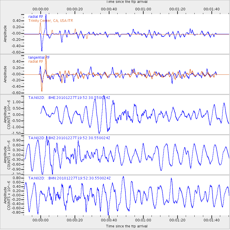
N02D Trinity Center, CA, USA - Earthquake Result Viewer
*The percent match for this event was below the threshold and hence no stack was calculated.
| Earthquake location: |
Vanuatu Islands Region |
| Earthquake latitude/longitude: |
-19.3/168.0 |
| Earthquake time(UTC): |
2010/12/27 (361) 19:40:12 GMT |
| Earthquake Depth: |
10 km |
| Earthquake Magnitude: |
5.5 MB, 5.0 MS, 5.5 MW |
| Earthquake Catalog/Contributor: |
WHDF/NEIC |
|
| Network: |
TA USArray Transportable Network (new EarthScope stations) |
| Station: |
N02D Trinity Center, CA, USA |
| Lat/Lon: |
40.97 N/122.71 W |
| Elevation: |
937 m |
|
| Distance: |
87.8 deg |
| Az: |
45.151 deg |
| Baz: |
242.164 deg |
| Ray Param: |
$rayparam |
*The percent match for this event was below the threshold and hence was not used in the summary stack. |
|
| Radial Match: |
78.83098 % |
| Radial Bump: |
400 |
| Transverse Match: |
63.592583 % |
| Transverse Bump: |
400 |
| SOD ConfigId: |
346175 |
| Insert Time: |
2011-05-25 02:01:06.663 +0000 |
| GWidth: |
2.5 |
| Max Bumps: |
400 |
| Tol: |
0.001 |
|
Signal To Noise
| Channel | StoN | STA | LTA |
| TA:N02D: :BHZ:20101227T19:52:30.550024Z | 2.300623 | 7.84811E-7 | 3.4112978E-7 |
| TA:N02D: :BHN:20101227T19:52:30.550024Z | 0.43441802 | 1.9093756E-7 | 4.3952497E-7 |
| TA:N02D: :BHE:20101227T19:52:30.550024Z | 2.3433614 | 9.260333E-7 | 3.9517306E-7 |
| Arrivals |
| Ps | |
| PpPs | |
| PsPs/PpSs | |


