You are here: Home > Network List > US - United States National Seismic Network Stations List
> Station ELK Elko, Nevada, USA > Earthquake Result Viewer
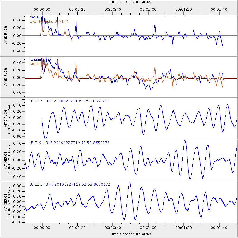
ELK Elko, Nevada, USA - Earthquake Result Viewer
*The percent match for this event was below the threshold and hence no stack was calculated.
| Earthquake location: |
Vanuatu Islands Region |
| Earthquake latitude/longitude: |
-19.3/168.0 |
| Earthquake time(UTC): |
2010/12/27 (361) 19:40:12 GMT |
| Earthquake Depth: |
10 km |
| Earthquake Magnitude: |
5.5 MB, 5.0 MS, 5.5 MW |
| Earthquake Catalog/Contributor: |
WHDF/NEIC |
|
| Network: |
US United States National Seismic Network |
| Station: |
ELK Elko, Nevada, USA |
| Lat/Lon: |
40.74 N/115.24 W |
| Elevation: |
2210 m |
|
| Distance: |
92.9 deg |
| Az: |
47.786 deg |
| Baz: |
247.018 deg |
| Ray Param: |
$rayparam |
*The percent match for this event was below the threshold and hence was not used in the summary stack. |
|
| Radial Match: |
54.320576 % |
| Radial Bump: |
400 |
| Transverse Match: |
50.17611 % |
| Transverse Bump: |
400 |
| SOD ConfigId: |
346175 |
| Insert Time: |
2011-05-25 02:01:59.414 +0000 |
| GWidth: |
2.5 |
| Max Bumps: |
400 |
| Tol: |
0.001 |
|
Signal To Noise
| Channel | StoN | STA | LTA |
| US:ELK: :BHZ:20101227T19:52:53.865027Z | 0.6905749 | 1.4318164E-7 | 2.0733688E-7 |
| US:ELK: :BHN:20101227T19:52:53.865027Z | 0.6933981 | 1.5122647E-7 | 2.1809471E-7 |
| US:ELK: :BHE:20101227T19:52:53.865027Z | 0.981314 | 2.5675826E-7 | 2.616474E-7 |
| Arrivals |
| Ps | |
| PpPs | |
| PsPs/PpSs | |


