You are here: Home > Network List > UW - Pacific Northwest Regional Seismic Network Stations List
> Station PASS Maple Falls, WA, USA > Earthquake Result Viewer
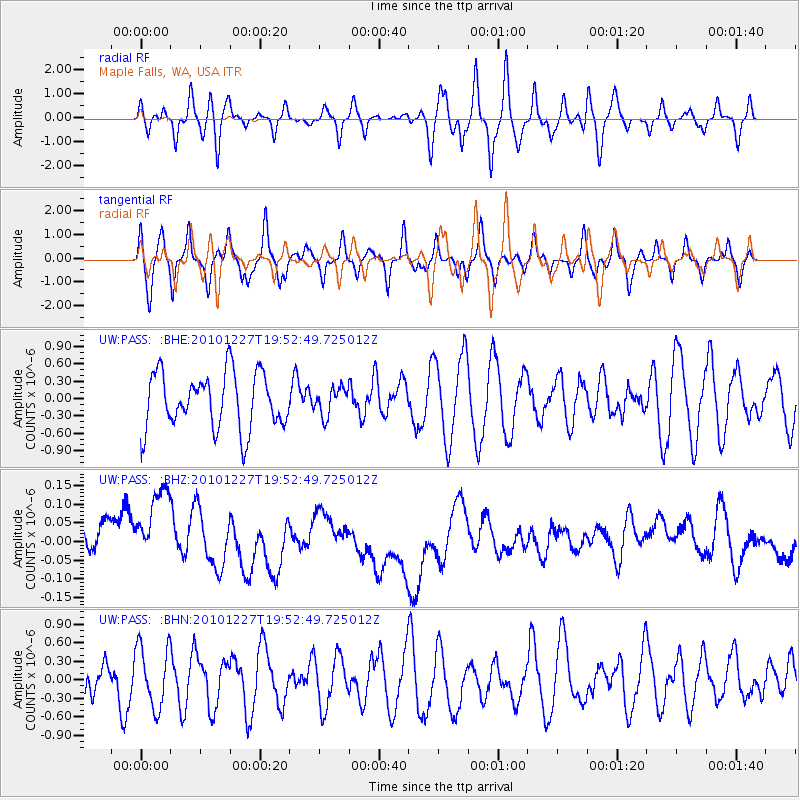
PASS Maple Falls, WA, USA - Earthquake Result Viewer
*The percent match for this event was below the threshold and hence no stack was calculated.
| Earthquake location: |
Vanuatu Islands Region |
| Earthquake latitude/longitude: |
-19.3/168.0 |
| Earthquake time(UTC): |
2010/12/27 (361) 19:40:12 GMT |
| Earthquake Depth: |
10 km |
| Earthquake Magnitude: |
5.5 MB, 5.0 MS, 5.5 MW |
| Earthquake Catalog/Contributor: |
WHDF/NEIC |
|
| Network: |
UW Pacific Northwest Regional Seismic Network |
| Station: |
PASS Maple Falls, WA, USA |
| Lat/Lon: |
49.00 N/122.09 W |
| Elevation: |
174 m |
|
| Distance: |
92.0 deg |
| Az: |
38.247 deg |
| Baz: |
242.59 deg |
| Ray Param: |
$rayparam |
*The percent match for this event was below the threshold and hence was not used in the summary stack. |
|
| Radial Match: |
45.58483 % |
| Radial Bump: |
400 |
| Transverse Match: |
58.554413 % |
| Transverse Bump: |
400 |
| SOD ConfigId: |
346175 |
| Insert Time: |
2011-05-25 02:02:59.488 +0000 |
| GWidth: |
2.5 |
| Max Bumps: |
400 |
| Tol: |
0.001 |
|
Signal To Noise
| Channel | StoN | STA | LTA |
| UW:PASS: :BHZ:20101227T19:52:49.725012Z | 2.1773307 | 1.6449304E-7 | 7.554803E-8 |
| UW:PASS: :BHN:20101227T19:52:49.725012Z | 1.6042484 | 4.9751355E-7 | 3.1012252E-7 |
| UW:PASS: :BHE:20101227T19:52:49.725012Z | 0.49243087 | 2.3677731E-7 | 4.8083365E-7 |
| Arrivals |
| Ps | |
| PpPs | |
| PsPs/PpSs | |


