You are here: Home > Network List > US - United States National Seismic Network Stations List
> Station MNTX Cornudas Mountains, Texas, USA > Earthquake Result Viewer
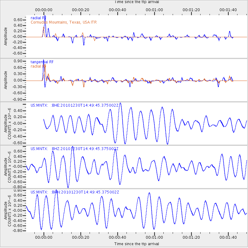
MNTX Cornudas Mountains, Texas, USA - Earthquake Result Viewer
*The percent match for this event was below the threshold and hence no stack was calculated.
| Earthquake location: |
Santa Cruz Islands |
| Earthquake latitude/longitude: |
-10.8/165.4 |
| Earthquake time(UTC): |
2010/12/30 (364) 14:36:54 GMT |
| Earthquake Depth: |
10 km |
| Earthquake Magnitude: |
5.5 MB, 5.5 MS, 5.6 MW, 5.6 MW |
| Earthquake Catalog/Contributor: |
WHDF/NEIC |
|
| Network: |
US United States National Seismic Network |
| Station: |
MNTX Cornudas Mountains, Texas, USA |
| Lat/Lon: |
31.70 N/105.38 W |
| Elevation: |
404 m |
|
| Distance: |
95.0 deg |
| Az: |
58.818 deg |
| Baz: |
260.422 deg |
| Ray Param: |
$rayparam |
*The percent match for this event was below the threshold and hence was not used in the summary stack. |
|
| Radial Match: |
70.812546 % |
| Radial Bump: |
344 |
| Transverse Match: |
54.52547 % |
| Transverse Bump: |
400 |
| SOD ConfigId: |
346175 |
| Insert Time: |
2011-05-25 02:34:19.933 +0000 |
| GWidth: |
2.5 |
| Max Bumps: |
400 |
| Tol: |
0.001 |
|
Signal To Noise
| Channel | StoN | STA | LTA |
| US:MNTX: :BHZ:20101230T14:49:45.375002Z | 1.1572182 | 3.614986E-7 | 3.1238585E-7 |
| US:MNTX: :BHN:20101230T14:49:45.375002Z | 2.7118132 | 4.8042125E-7 | 1.7715868E-7 |
| US:MNTX: :BHE:20101230T14:49:45.375002Z | 0.82546455 | 1.4360597E-7 | 1.739699E-7 |
| Arrivals |
| Ps | |
| PpPs | |
| PsPs/PpSs | |


