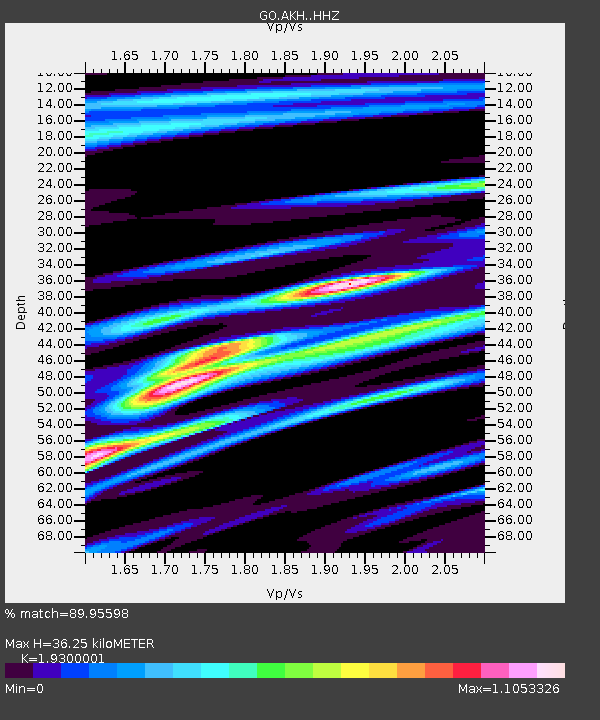
AKH Akhalkalaki - Earthquake Result Viewer

Earthquake location: Puerto Rico Region
Earthquake latitude/longitude: 19.0/-66.8
Earthquake time(UTC): 2014/01/13 (013) 04:01:03 GMT
Earthquake Depth: 20 km
Earthquake Magnitude: 6.4 MWW, 6.2 MWB, 6.3 MWC, 6.4 MI, 6.4 MWC
Earthquake Catalog/Contributor: NEIC PDE/NEIC COMCAT
Network: GO National Seismic Network of Georgia
Station: AKH Akhalkalaki
Lat/Lon: 41.41 N/43.49 E
Elevation: 1720 m
Distance: 91.9 deg
Az: 44.898 deg
Baz: 297.418 deg
Ray Param: 0.04153612
Estimated Moho Depth: 36.25 km
Estimated Crust Vp/Vs: 1.93
Assumed Crust Vp: 6.419 km/s
Estimated Crust Vs: 3.326 km/s
Estimated Crust Poisson's Ratio: 0.32
Radial Match: 89.95598 %
Radial Bump: 383
Transverse Match: 74.28126 %
Transverse Bump: 400
SOD ConfigId: 3390531
Insert Time: 2019-04-09 23:43:23.976 +0000
GWidth: 2.5
Max Bumps: 400
Tol: 0.001

Signal To Noise

ChannelStoNSTALTA
GO:AKH: :HHZ:20140113T04:13:38.770029Z2.9175626.333025E-72.1706565E-7
GO:AKH: :HHN:20140113T04:13:38.770029Z0.57919952.776624E-74.793899E-7
GO:AKH: :HHE:20140113T04:13:38.770029Z1.13633193.6186663E-73.1845153E-7
Arrivals
Ps5.4 SECOND
PpPs16 SECOND
PsPs/PpSs22 SECOND